Monday, December 19, 2011

2011 - June 14th - Grand Mesa In Spring, Plateau Creek & Colorado River (Both At Flood Stage)

After spending a lot of days off in the lower canyons, the frozen Grand Mesa seemed locked away in the clouds for most of the spring.  I did want to get up and do a bit of exploring, though.  As late spring pressed on, the rivers and streams began to fill with late season snow-melt, which had until then, been withheld. 

I spent the previous "weekend" storm chasing out east, so I was looking for a different kind of adventure.  I hit the road after dinner and made my way for Grand Mesa, first following the twisting turns of I-70 in the De Beque Canyon and then those of Colorado 65 in the canyon carved by Plateau Creek. 

I had only taken the highway past the small town of Mesa, Colorado on one previous occasion and knew I'd find the scenery to be quite different on this second trip.  After the turnoff to the area's closest ski resort, Powderhorn, the highway switches back up the north face of Grand Mesa.  I was keeping my eyes open for a possible waterfall in the area since I had heard rumor of one visible from the highway, but I wasn't able to locate it.

As the road really starts to pick up elevation, drivers get their first terrific view after rounding Spruce Point...


The view down from the highway just "uphill" from Spruce Point.

Of course, it helped that the evening light absolutely lit up the unbelievably green north side of the mesa.  The view really was spectacular.

The road levels off a bit after Spruce Point and winds through the forest and ponds of Mesa Lakes.  Even in mid-June, the Aspen were just beginning to leaf-up.  Piles of snow still remained in shadowed areas and blocked turnouts to picnic areas and campgrounds. 

Looking through the aspen to Mesa Lake.

I stopped occasionally for photos, but continued on up the highway.  The highway holds one more steep switchback up the basaltic edge of Grand Mesa's cap rock.  As I reached the top, I was greeted with yet another incredible view from Skyway Point. 

Water Dog Reservoir from Skyway Point. 

Once atop the mesa, the highway levels out and it is incredibly flat.  The drive across the top however is relatively short and can be accomplished in a matter of minutes.  Then, the road descends down the south face of the mesa.  Much to my surprise, I found the first lake (Island Lake) on the south side of the mesa to be completely frozen (while the lakes on the north face were not!).  Don't ask me to explain that.

The light was getting low and I didn't have a lot of time to explore, so I turned around shortly after dipping a little south.  I noticed that when looking to the east-southeast, the fullish moon had just appeared brightly over the West Elk Mountains. 


Upon returning to the top of the mesa, I spotted a cascade to my right and less than a quarter mile off the road.  I decided that I could probably reach it even though I was wearing shorts and sneakers (highs in the valley were in the 80s that day)... and even though I would have to cross a snow field to get there.

So, I started walking.  For the most part, I was able to stand atop the hard, frozen crust of the snow.  Occasionally, I would break through.  The snow was about a foot deep in most places... and moreso in others.  For example, several hidden waterways crossed under the snow, unbeknownst to me.  I found them quite easily and on several occasions, found myself half-thigh in unbelievably cold slush.

Eventually, after zig-zagging to a couple of rocky outcrops, I reached spitting distance of the cascade... which I then realized to be the outlet of a reservoir.  That's no cascade, it's a spillway.  (Star Wars, anyone?)

I moved around the area looking for a good shot and successfully breaking through the snow several times to find very cold pools of water.


The pussy willow lining the outlet.


Eventually, I became cold and returned to my vehicle.  Don't worry, I fell through the ice several more times on the way back. 
The distant spillway and outlet; headwaters for Kannah Creek.

Another reservoir (Grand Mesa Reservoir #9, I believe) on the west side of the highway.


As the sun set, the sky lit up for a few moments with tremendous color...


I was marveling at how it was so warm in the valley and I had my heat on "floor", full-blast as I hit the highway once again.  In the fading light, I stopped at Skyway Point once again for shots of the dramatic dusk.

Light reflecting off of Rapid Creek Reservoir .


Light had faded by the time I reached the Powderhorn turnoff and at that point, I was content to head on home.

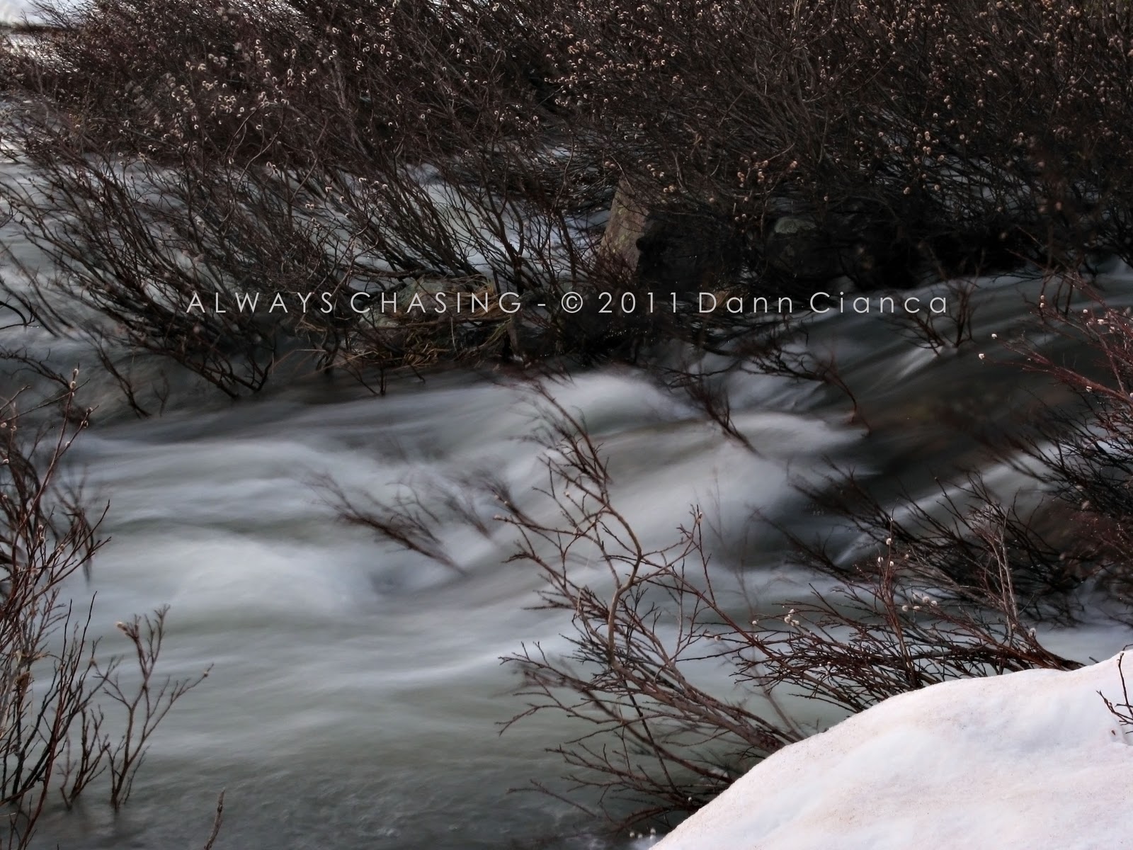
However, as I reached the canyon carved by Plateau Creek, I couldn't help but notice how bright the moon was and how well the flood-stage creek was illuminated.  Thus began another phase of my expedition. 


Unfortunately, since the canyon is pretty tight, there wasn't much in the way of good access to the "creek" in photogenic places.  I had to do a lot of guard-rail hopping and bushwhacking to get to the water.  The water, swollen from its banks also did a good job of flowing through the bank-side vegetation, which further hampered access.   I did try my best. 

I call it "the wave"


While photographing the canyon from the road, a county sheriff's deputy pulled up with lights on, questioned what I was doing and then moved on. 

I decided to move on as well.  My legs were starting to get itchy for whatever reason.  But since I was in a picture-taking mode, I also tried to stop alongside the flood-swollen Colorado River in the De Beque Canyon as well.  I found a good place to pull off at the first Palisade exit, before the river departs the canyon.  The canyon itself was illuminated by the moon with the water lit from the highway interchange lights. 


I was having fun taking pictures, but my legs were driving me absolutely crazy and my eyes were beginning to swell also.  To this day, I'm not exactly sure what was bothering my allergies, but I would wager it was either a mold in the snow that I had been tromping through or the grass alongside Plateau Creek. 

I had allergy tests done a few years back that showed an allergy to "redtop" grass.  I've never really had any problems with "hay fever" and my strongest allergic reactions have always been to cats.  The test showed I was more allergic to this type of grass than to cats.  But I find that it grows all over and I've never had much of a problem, so who knows. 

I did head across the river in Palisade to get a late-night shot of ol' Mount Garfield once before heading home, however.  It's such a stoic monument. 

Dann.

Friday, November 25, 2011

2011 Storm Chase 9 - June 8th - Chugwater, Supercell City

I had a dental appointment in Brighton, Colorado on June 7th.  It was a Tuesday, my day off.  I had originally hoped to be able to chase after the appointment but as the day approached, that chance looked less favorable.

To be honest, I was fine with that result.  The following day looked promising and I would have an opportunity to see friends and family in Denver.

I hit the road early on the 7th and as  you can see, winter hadn't quite given up its grip on the Colorado mountains...

Vail Pass

After getting a permanent crown put over one of my back molars, I got in touch with Tony Laubach to see if he wanted to get some lunch.  I had left my lights on and somehow depleted my battery during my two hour appointment, so I was very fortunate to have him give me a jump.  I returned the favor with a little Chipotle in Westminster.  After trading war stories with Tony, i.e. catching up on the *real* storm chasing season so far on the opposite side of the hill, I headed south to meet up with another good friend, Johnathan Skinner.  He was in the process of getting his oil changes, as we like to say, so I hung out with him and his mom for a while.  It was good to catch up.

Then it was north to Thornton to visit with my family for a while before meeting up with a bunch of friends at Buffalo Wild Wings in Northglenn.  It was great to sit back, have a couple beers and a bunch of wings with some awesome people. 

The next morning, I met up with Scott Hammel and we began our push north into Wyoming.  There wasn't much going on in the upper levels that was impressive but southwesterly flow.  It was strong enough to draw surface moisture up the slope, though, in the lee of the mountains.  On days like this, you just hope for a weak disturbance to move by in the flow to help light the fuse.  SPC had a slight risk up for my target our target of Chugwater, Wyoming.  Surface dew points in southeastern Wyoming were in the mid-40s with brisk southeasterly winds.  We were hoping for enough moisture convergence along the dryline (which had yet to set up) or the lee trough (which had also yet to set up) to push 50ºF (Td). 

As we reached Chugwater, the skies were quite clear.  SPC had trimmed down the "slight" risk out of southeastern Wyoming, but I did not agree with that forecast.  I still thought we were just as likely, if not more likely to see severe weather in southeastern Wyoming than in northeastern Colorado.  So, we stayed put.

 It was around lunch time and I had always wanted to try the infamous Chugwater Chili.  Living in Colorado with most of my family back in Montana had resulted in many drives through the small Wyoming town.  It's hard to miss the billboards.

With some time to kill, we stopped in to the Chugwater Soda Fountain for a bit of lunch.  I had to order the chili, of course, and paired it with an absolutely exceptional chocolate malt.  The chili did not disappoint.  I've had a lot of chili that is overdone with different ingredients. This chili is simple, but perfected... which I suppose is the best way to describe it.  It's the type you could eat for several meals in a row and not get tired of it.


Try the chili... and don't forget the chocolate malt.

With full bellies, we wandered just a bit east of town to perch on the high bluffs and watch the west.  Small cumulus were beginning to form on the Laramie Mountains but for a while, it was nothing impressive.  I was quite content to be outside, enjoying that unique feeling of being in moist, southerly flow.  It's something you don't feel in the desert.

Slowly but surely, the cumulus over the mountains began to grow.  SPC's updated outlook showed no real change to their forecast and I felt no different about mine.   At just a little after 2000Z, the cap started to break and towers went up.  We chose a storm coming off of the mountains southwest of Wheatland and headed north to intercept.  We left the interstate (25) on Wyoming 34 and headed west a bit to observe.  

First storm of the day.

Unfortunately, it didn't look all that impressive.  We paced the back roads, north to south to keep an eye on it, but it never really seemed to get its act together.

We're losing it!

Around this time, SPC issued Mesoscale Discussion #1138 which included our area and mentioned the possibility of a weather watch.

Interestingly, there was no dryline or lee trough... at least on the east side of the Laramie Mountains.  The surface moisture had penetrated the frontal range and was making it west to the basins beyond.  Convection was firing west of the mountains as well and some of it looked strong.

I suggested to Scott that we get aggressive and head into the mountains for an intercept.  He concurred.  I plotted a course for us on a dirt road that twists and turns through the foot hills and meets the Laramie River.

We were lucky to have a strong storm developing just to our west as we entered the mountains.  It was my favorite kind of chasing: all visual and paper maps.  Neither of us had any sort of mobile phone reception whatsoever.

Though the horizon was often blocked by hills, we finally emerged and were able to get a good luck at what was heading our way... and it looked good.  The area was reasonably photogenic, so we stopped for a few frames.

Strong base.


Yucca.


Feeling pretty confident that we had a good bead on the storm, we continued west to get closer.  Again, our path was wrought with visual obscuration but we caught occasional glimpses of the hard and flat base; enough for us to know that the storm was strong. 


Eventually, we found ourselves in a valley, alongside the flood-stage Laramie River.  The updraft of the storm was upon us and the sky was absolutely gorgeous.


I made my way through the willow to stand beside the river and take in the view, more reminiscent of a stormy day in southwest Montana (back home for me) than any place I had ever chased.  I took a few longer exposures as we suddenly found ourselves in dry outflow winds. 


 I recall hearing a strange splash and filed it to the back of my brain.  As I started heading back to the car, something flew through the shrubbery nearby.  I thought that Scott had thrown something at me, but when I saw another object fly into view and hit the ground in front of me, I realized it was hail.  This, as you can imagine, hastened my return to the vehicle.  We both had a good laugh as the hail began to pour to the ground around us. 


The birds don't look too happy.


Back on the road, we turned around and headed back.  The storm was now on its way to the plains and we figured we ought to be too.  The back side of the storm was stunning.  I've seen dark, rain-free bases over the plains before, but to see it over the varied terrain of the mountains was spectacular. 

Bonus rear flank downdraft!

This has to be one of my favorite images of the day, if not year.  The sky was so dark and ominous and the way that the sun seemed to sneak under and illuminate the peak was incredibly pleasing.

Yes, she's a hail-maker.

As we reached the plains and hit the pavement, I struggled to submit a hail report (from our time in the mountains), but we had a hard time locking on to a signal.  On radar, the storm had a decent couplet, but visually, there wasn't much of a lowering.  Soon, we found ourselves back on I-25, headed north for Wheatland so we could have an east option on the storm.  And then we got back into the hail.

Huge slush balls! 

Unfortunately, the storm began to take a right-turn and we found ourselves out of position in Wheatland.  We took a moment to collect hail.  Most of the bigger stones were conglomerates of smaller ones and most seemed to attain a flat shape as they impacted the ground.  Pancake hail?


Somewhat behind the storm, we tried to catch up, but our road options ended abruptly with bad map data (both in paper and digital) at the rim of the Goshen Hole.  Out of position once again, we were forced to back track and head south.  By this time, we found ourselves in the storm's wake... which was a haily, slushy mess.


Hail fog!


As the storm continued off to the east, we kind of gave up on it.  Looking back to the mountains yielded nothing impressive in the way of convection either.  There were a couple of storms just east of Denver, but they looked marginal at best.  I did have to be at work the next morning at 9:30AM and we already felt rather pleased with what we had seen, so we started making our way back south.

This turned out to be a good move for two reasons.  1: Our first storm died a quick death near Torrington.  2: Convection began to fire near Cheyenne. 

Hey!  We were just west of Cheyenne.  Quickly, a supercell formed.  We just parked alongside the road and took some photos as it developed; timed perfectly with sunset, of course.


A big transport plane takes off from Cheyenne, under the storm's base.


It started to move off to the northeast and diminish in intensity, but it was putting down some good lightning.  We scooted north and tried to get out of the anvil spit to grab a couple of shots.  I found the wind difficult to reckon with, even with my tripod, so I only manged a few bolts in frame.


As activity began to die down in Wyoming, more storms popped in northeastern Colorado on the south side of the Cheyenne Ridge.  We dropped directly south on WY 214 and then into Colorado on county roads.  We passed through a couple of thundershowers before emerging with a fantastic view to our west near Briggsdale.  We opted to continue a bit farther south and stopped at Cornish, which isn't much more than an intersection.  But there we sat for the better part of an hour, taking pictures of a beautiful supercell to our west.  Below is a series of images showing the evolution of the storm, often lit by lightning flashes and the city lights of Greeley, Colorado.  Occasionally, the storm produced a stubby lowering, but never really looked more impressive than that. 


Almost looking a little wedding cakey.

Self-portrait.

And Scott capturing the moment.


Eventually, the structure faded and the storm began to die.  While another strong storm formed west of it, i would say that we were pretty satisfied at this point.  We headed into Greeley where we picked up some late-night Wendy's.  Though we were "done", storms to our northwest still occasionally captivated our attention while we continued south. 

Another storm near Fort Collins.

Eventually, we made it back to Thornton where I bid Scott farewell and hit the road over the mountains so I could get to work in the morning.  It was a long drive, but I was pretty pumped from another exceptional and fortunate plains chase. 

STATS
Mileage: 571
2011YTD Mileage: 1405
States: Wyoming, Colorado
SPC Risk: Initially Slight, Reduced To Probablistic
Max Hail: 3" (flats)
Tornadoes: 0
Other Phenomena: Structure, Hail Fog
Storm Reports for June 8th

Scott's "Teaser" Report from June 8th

Detail Map:

Dann.