Monday, June 27, 2011

2011 - March 23rd - Devils Garden Section, Arches National Park

Sorry for four hundred posts regarding this trip, but I took a lot of pictures and we fit a lot into one day!  We left off after hiking to Sand Dune Arch, Broken Arch and Tapestry Arch.  It was still only mid-afternoon and I had my eyes on the Devils Garden area just to the north.  There are a lot of arches in this area including the famous Landscape Arch.

Along the road, we spied Skyline Arch and though we did not hike to it as a group, I ran half-way up the trail for a couple of snap shots before returning to the car and an ice cold Hansen's Creamy Root Beer.  Thank you, cooler-packing foresight.

Skyline Arch


After our brief stop at Skyline Arch, we arrived at the crowded Devils Garden trailhead.  We debated the extent of our adventure here as I tried to schedule a sunset visit to Delicate Arch.  We figured that we would at least get to Landscape Arch and see where we could go from there.

The hike to the arch was maybe a half hour at the most and though the light was terrible for pictures, I still found the sight of it quite substantial.

Landscape Arch


We played around for a while, trying to find a good angle for a photo but I wasn't all that satisfied with what I could find.  I decided to continue farther on the trail.  Though I wasn't planning on leaving Kendell and Katherine, I wanted to see if I could get a different view.

The climb was somewhat challenging as the trail follows the spine of a sandstone fin.  From this area, I was able to view the now-collapsed Wall Arch.  The collapse happened back in 2008. This area also gave me spectacular views back along the trail and to the distant La Sal Mountains and to Partition Arch.


Partition Arch

When I returned to the bottom, I tried another shot of Landscape Arch with the sun directly behind the rock, but I still don't think it turned out very well.


One of many interestingly shaped rocks.

Partition Arch from a different angle.


I found Kendell when I returned but not Katherine.  We both backtracked to find her but to no avail, so I headed on back toward the trailhead.  I asked that Kendell head toward Pine Tree Arch, another that we planned to visit.  The trail for that arch splits from the main trail after the trail head and the plan was to catch it on the way back anyway.  To make a long story short, I eventually found Katherine near the trailhead and she accompanied me to meet up with Kendell on the Pine Tree Arch trail.  And that's where we ran into the deer. 


And it was a rather friendly deer.  I guess that's what you get in the National Parks.


Inspector LaRoche is fooled by the doe's invisibility cloak.


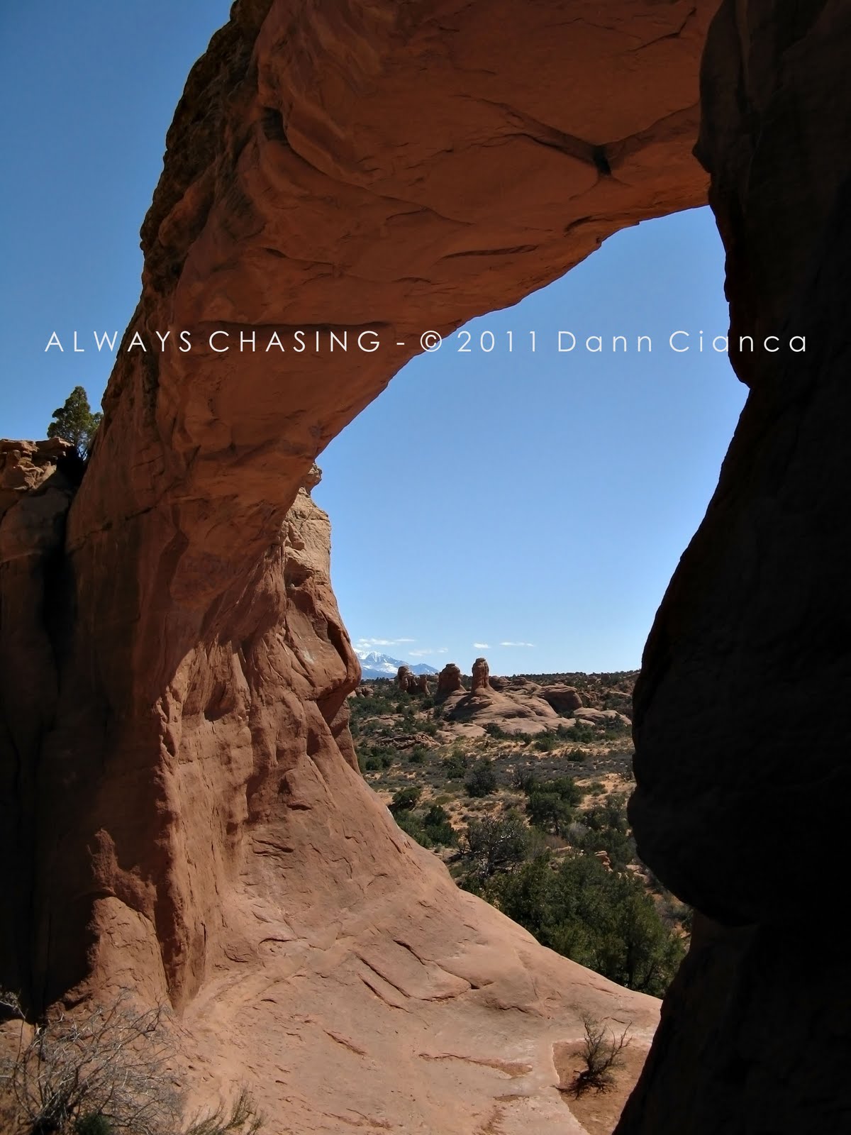
Finally, we reached Pine Tree Arch, which turned out to be one of my favorites from our trip. 

Pine Tree Arch


From the light-side.


Tunnel Arch
 
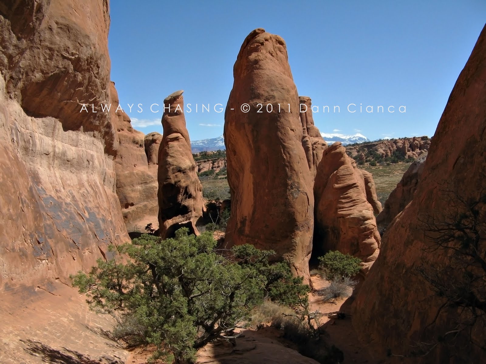
Out through the fins of the Devils Garden.

I think everyone was a little tired from driving around and hiking in the 50ºF heat, but I wasn't done yet. We still had the Park's Delicate Arch to visit.  It is perhaps the most famous arch from the park and it even adorns the state of Utah's license plates.  As we left the Devils Garden area, we were right on schedule to visit Delicate Arch for sunset. (and that will be the final installment from this trip!) 

Dann.

Friday, June 24, 2011

2011 - March 23rd - Sand Dune, Broken & Tapestry Arches, Arches National Park

Where did we leave off? Ah yes, Arches.  (The first part of this trip can be found here in a previous entry.)

After exploring the Balanced Rock area, we took a quick pause at the Fiery Furnace.  Since this area requires either a hiking permit or a reserved guided tour, we continued on.  The next stop on my list was Sand Dune Arch due to its proximity to the road.  I figured if we had time, hike on another mile or so to Broken Arch at that point.

While we could see several arches at a distance in The Windows Section but had not had the opportunity yet to view an arch, up-close.

The trail to Sand Dune Arch is short and only leads a short distance from the parking lot to a gap between sandstone fins. The trail is easy and only requires a small step-up between fins.  Otherwise, it is completely sand.  We passed by the arch originally and continued farther between the fins as several groups of people were exploring the area.  I wanted a shot without humans in it.  This lead us to several areas were one could climb into narrow spaces between the fins.  Many jokes of 127 Hours ensued. 


Between The Fins


Kendell & Katherine Moments Before Arm Amputations


As people cleared out, we returned to the arch... the first arch of our Arches experience and took a few moments to get some photos.

Sand Dune Arch


Textures

Realizing that we had plenty of time on our hands, I suggested we continue on to Broken Arch, which wasn't too far away.  The trail was mostly sand again and along the way, signs asking visitors to keep off the soil crust were common.


The arch is actually visible from the Sand Dune Arch area, but the trail moves in and hugs another area of sandstone fins, disrupting the visibility.  When we finally emerged, however, we were greeted with a spectacular view.

Broken Arch

We spent five or ten minutes looking for different angles to take photos and enjoying the natural beauty.

Yucca Man, Terror Of The Arches


Katherine Under Broken Arch For Scale


We were feeling ambitious and decided to follow the trail through the arch and make a loop back to the parking lot.  I wasn't completely sure how long this would take, but we decided to do it anyway.  Along the way, we saw a sign pointing to a distant cliffside arch that we could see called Tapestry Arch.  We took this side trail and visited that arch as well.

Tapestry Arch (right)


A Raptor Of Some Sort Acting As Guard


Kendell Under Tapestry Arch For Scale

We rejoined the trail and followed it through the Devils Garden Campground, which marks the apex of the loop.  From there, we continued back south toward the original trail head.


Open Country To The Northwest
 
Looking Back At Tapestry Arch

The trail did actually work its way back through several sandstone fins before the loop ended.  The alignment of the fins provided a perfect view of the distant, snow-capped La Sal Mountains.


As we returned to our hot vehicle, it was still only early afternoon.  The Devils Garden area was next on our list. 

Dann.