Sunday, February 26, 2012

2011 Storm Chase 13 - July 6th - Lightning Finally Strikes In The North Desert

When I moved to the Western Slope, I knew that storm chasing opportunities would be few and far between, but I found solace in the fact that the monsoon would bring good lightning.

Monsoon moisture began to work its way into the area in mid-June and I spent quite a few nights trying to get a bolt in frame; a task which seemed easy at times in the Front Range.  I was finding it quite difficult on the Western Slope, however.  But that didn't deter me.  I obediently drove into the desert at any threat of late convection hoping for a chance.

On this particular Wednesday evening, the tail end of a shortwave riding atop the ridge was drifting through northwest Colorado.  It had been quite hot during the daytime and relatively moist for the desert.  As night began to fall, the dewpoint increased into the 50s.


In the early evening, storms began to fire over the Tavaputs Plateaus in eastern Utah and then drifted across the border.  I left my house after 8PM or so and drove west on I-70.  I left the highway at Loma and then drove north on Colorado 139 out of the irrigated valley and into the rolling hills of the desert.

I recall the surface winds being pretty strong as I pulled to the side of the road to shoot.  As the storms road the Book Cliffs to the north, they began to fizzle to some extent.  Still, there was a bit of lightning and out of persistence, I was able to capture my first Western Slope spark in frame.  It's nothing exceptional, but at the time, I was relieved and excited. 

Intra-cloud lightning over Book Cliffs.

I stayed at that spot for about a half hour before the storms really died down.  Though the first lightning shot was the best, I was able to take a couple of images that were keepers of some sort; at least showing the scene in a way that I wanted to keep.

Looking north-northwest on Colorado 139 toward the Book Cliffs.

Lightning illuminates the crest of the Book Cliffs

Satisfied, I headed home.  My first non-bust lightning chase of 2011 on the Western Slope!  Luckily, it wouldn't be my last. 

Map:


STATS
Mileage: 44
2011YTD Mileage: 1646
States: Colorado
SPC Risk: Categorical
Max Hail: None
Tornadoes: None
Other Phenomena:  None
Applicable Mesoscale Discussions: None
Applicable Weather Watches: None
Storm Reports for July 6th

Dann.

2011 - July 7th - Piñon Mesa, Grand Mesa National Forest (Fruita Division)

The Uncompahgre Plateau is cut east to west by the Unaweep Canyon. North of the canyon is a raised area known as Piñon Mesa. From the valleys east or west, the grade is rather gradual, so it is surprising that the flat-topped and broad mesa tops out over 9,700ft. In fact, it is almost as tall as the Grand Mesa, the much more remarkable feature which lies to the east of the Grand Valley.

At about 8,700ft, the forest changes over from Piñon-Juniper to a mix of Quaking Aspen, Douglas fir (I presume) with a some oak scrub mixed in.

I had been wanting to explore the Piñon Mesa area and its various reservoirs for a while. While the valleys were baking in the mid-90s and I was looking to escape to some place cooler. I recruited my friend Shannon for a nice high-altitude adventure and we hit the road early in the morning to best avoid the heat.

The Fruita Division of the Grand Mesa National Forest can be reached via Glade Park, southwest of Grand Junction. We took S 16 1/2 Road south from the Glade Park Store as it slowly gained elevation and transitioned to gravel into the Piñon-Juniper.

At about 8,600ft, the road breaks out into broad meadows. As we approached the forest service boundary, the meadows began to take on a very bright color. It was only about 8:30AM and though there were a few high clouds, it was a gorgeous morning.  And the wildflowers, well, they were fantastic. 


We stepped out of the vehicle for ten minutes or so to enjoy the surroundings... and avoid the bumble bees.


We weren't quite at the trail head, however, so we got back in the vehicle and continued on. We planned to hike from Fruita Reservoir No. 1 across the crest of the Mesa and down to Black Pine Reservoir on the other side, roughly five miles round-trip with 400ft of gain on the way to the top and 300ft on the way back up from the other side.

The trail starts pretty close to the Fruita Reservoir No. 1 (not pictured) which was a little stinky and filled with algae.  Swarms of insects also loudly hovered near the water.  From what I understand, the reservoirs were initially intended to provide water to Fruita but a pipeline that would have gone through the Colorado National Monument either was rejected or an existing one was not allowed to be repaired.

The trail continues south along the length of the west side of the reservoir.  We were briefly distracted by strange noises from the nearby forest.  Initially, I thought it might be a turkey, but I eventually discovered it was a raven.

The trail climbs west up a drainage south of the reservoir.  I got a little winded thanks to the elevation and was also on spider-web patrol, using my face to break through any rogue strands that crossed the trail.  As we neared the top, I spotted a nice columbine along the trail. 


At the top of the mesa is a beautiful grove of old aspen.  We lingered for a while, enjoying the sun which filtered through the leaves.


Oh, and I found a caterpillar too.  I'm not sure what it was destined to become, but I posed with it for a moment. 

After starting to descend the other side, I noticed that the trail had become a stream and I think both of us were not necessarily looking forward to hiking down and then back up again, so after hanging out in the aspen grove for a while, we returned the mile and a half to the trail head, satisfied with what we had accomplished.

Back in the car, we stopped once more near the boundary for wildflower photos...


Shannon hadn't taken the entire drive through the Colorado National Monument yet, so we decided to head through and exit near Fruita.  Here are a few bonus photos of Independence Monument:


Once in Fruita, we stopped in the Hot Tomato for a pizza.  We had the Vortex Pizza.  The name sold me but it was absolutely delicious too.  Added bonus!

Though it was a rather short hike, I found it to be a fantastic way to escape the summer heat and enjoy a morning outdoors.

Map:


Dann.

Monday, February 20, 2012

2012 - February 13th - Hunter Canyon

Mondays have become "Adventure Mondays," which I have to say is pretty awesome.  My friend and co-worker Shannon shares Mondays off of work as well as my spirit for adventure.   Since I was dealing with my back issues the previous week, I had to cancel.  However, after heading out just a few days before for a leisurely hike through Ladder Canyon, I realized that a longer hike was probably okay. 

I was trying to think of some place that didn't have a lot of elevation gain just to take it easy on myself and realized that I wanted to visit Hunter Canyon again.  I had done so previously in October (that post has not been written yet), but thoroughly enjoyed it.  I was eager to show Shannon some of the unique features of this nearby yet remote canyon. 

The canyon is carved by Little Salt Wash into the Book Cliffs, which bound the northern perimeter of the Grand Valley.  It is accessed by 21 Road, which is paved half-way across the desert.  The road actually enters the canyon, which has impressive, towering gates.

I parked at the same place that I had done previously, which is the first crossing of the wash.  Like my previous trip, there was actually water flowing in the wash.  This time, however, there was actually some snow in the shadowy areas.  Precipitation had moved through the area the day before which resulted only in rain in the city, but the Book Cliffs had a nice dusting on them.  And, as it turns out, the canyon also suffered a nice coat.

The first thing we noticed on our hike was the mud.  It was muddy... everywhere.  Even the snow had mud in it.  I'm not talking about mud that is a minor nuisance, I'm talking about mud that you sink into a couple of inches with each step.  It was nearly impossible to avoid the mud.

The farther we went into the canyon, the more snow we found.  Eventually, we found that walking on the frozen wash was a better idea.  In some places, the ice was rather thick.  By this time, the shadows of the canyon had kept most of the previous day's snow (and probably earlier season snow) intact.  With the snow, the going was actually easier.

In one strange moment, we actually observed a spider skittering across the snow.  That was a new one.

One of the most impressive features in Hunter Canyon is the big alcove.  It has been described as "wide enough to drive your truck through."  And in fact, many do.  At one time, I understand that the BLM did plow a road through the canyon, but flash flooding had done quite a number on it, washing it out in several places.  It is no longer considered a navigable road.

Back to the alcove, it doesn't really compare to the incredible Mee Canyon Alcove, but it's definitely the second best that I have seen. 

Approaching the alcove.

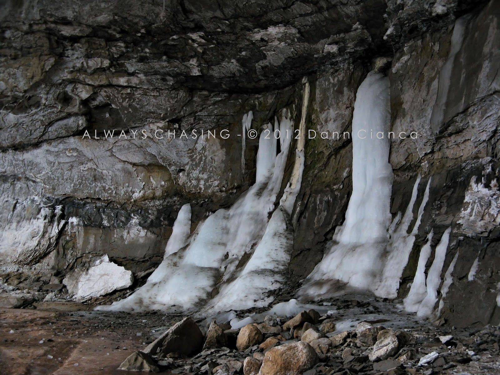
The wash was completely frozen inside the alcove, which wasn't too much of a surprise.  I pulled out my tripod to take a few longer exposures while Shannon rested and marveled. 

Ice flows.

Shannon for scale.


Another thing you'll notice inside the alcove is the powerful sulfur smell.  There are many coal seams exposed in the canyon and a lot of gasses escape.  It seems particularly strong in this alcove.  It's so strong, in fact, that your intuition says: "don't stay long"

On our way out, I noticed that a large, recent rockfall (not pictured) is now blocking up the entrance to the canyon.  It would now be quite difficult to take even a high-clearance vehicle all the way through.  

So, we didn't.  We continued up-canyon with intentions of exploring a side-canyon which I find to be quite remarkable.  The sun started to peek out a bit too, which only made the fresh snow on the incredible terrain sparkle even more. 


A towering hoodoo, overlooking the wash.

We also stopped for a few minutes at a place I like to call "Dann's grape-eating station."  It isn't really anything to clever, rather just a place I had stopped on my previous journey to eat a branch of grapes.  I have fond memories of those grapes.  There, I took a few more photos.


Around the next bend, the canyon forks.  We followed the smaller tributary to the east.  I had explored this canyon previously as well and found it to be awesome. 

An eastern fork of Hunter Canyon.


After a short while, we came across another alcove.  This one isn't quite as deep as the big alcove in the main branch of the canyon, but is certainly as scenic.

Looking upstream, into the alcove.

Looking downstream, from the other side.

The lip of the alcove almost touches the other side.  They are literally inches apart.

After navigating the alcove and trying not to fall through the ice, we preceded through what I call the "subway" (pictures below), around a very tight corner to a small waterfall (not pictured).

Well, okay, here's a picture from back in October...

(mobile phone image from October 11th, 2011)

... just picture it frozen over now.  Unlike my previous venture, we were able to walk up to it since the pool was frozen over.

While the waterfall is cool, I think the short, tight canyon leading up to it is the best part of the canyon.  Luckily, I remembered to take a few photos on the way out!


Shannon (I can only assume) marveling at the amazing scenery.

I only fell through the ice once on the way out and since my boots had already become muddy and wet earlier, it wasn't too much of a deal.

Once we returned to the main canyon, we continued exploring upstream for a while.  I wanted to at least go to the next alcove (not pictured).  That's where we turned around.  The upper alcove is actually pretty deep, but cut off from the wash.  The floor of the alcove is probably at least ten feet higher in elevation than the wash.  I'm not sure how long it has been cut off.  It is possible that when they put the road through, that changed the course of the water.

On the way out of the alcove, Shannon easily walked down a snowy slope while I resorted to using my backside as a bobsled.  +1 for me.  I'm not going to lie, it was a lot of fun.

From there, we worked our way back out of the canyon.  Since it was a bit warmer, there was more mud, which was a little annoying and a couple of places that were solid ice were now flowing water and slush.  With the warm, convection was popping along the Book Cliffs which led to occasional snow/grauple showers.  So, it was a little messy, but we made it back, pleased with our adventure.  We then capped off the adventure with some hot soup and cheddar bay biscuits from Red Lobster.  That's what I call a complete adventure.


Oh yeah, we also saw a turkey vulture.  True story.

Dann.

Saturday, February 18, 2012

2012 - February 11th - Rough Canyon & Ladder Canyon, Bangs Canyon Special Recreation Management Area

Normally on a Saturday morning, you can find me playing flag football, but after injuring my back the previous week, I was on my second week of sitting out and itching to get some sort of exercise. I had intended to at some point and time go on a hike with my friend Janelle, but our schedules had always been in conflict.  I realized that this would be a good opportunity and invited her along for what I planned to be an easy and short hike.

Regarding my back injury, I had felt a tightness in my lower back while playing football and eventually left the game when it really started to freeze up.  I was also feeling nerve pain in my right leg which was not good.  I significantly herniated a disc in my back in late 2007 and dealt with a lot of pain for about six months before getting a couple of spinal injections.

Since then, I haven't had much trouble save for the occasional tweak, usually when I pull/strain a muscle in my back.  This was different however, for about three days, I was incredible pain once again.  It hurt so bad, I couldn't roll over in bed.  Sitting was okay, standing was a struggle, but after a couple of days, the pain vanished, so I didn't go to the doctor.  Anyway, I am taking a couple of weeks off of playing football and basketball and keeping my hikes in less-strenuous territory.

This was going to be one of those hikes... the less-strenuous variety.  I thought of an easy hike that I wanted to accomplish in the winter anyway: revisit the waterfall past the mica mine in Ladder Canyon to see its winter state.

Another friend, Spencer, also decided to join us, so we hit the trail on a cloudy February morning.  I knew the cirro-stratus was going to make photography terrible, but I really just wanted the exercise.

Joining the three of us was Janelle's dog Dierks, who I'm sure was enjoying some time outside.

There was a surprising amount of snow in the canyon, considering that the valley hasn't seen much this year.  We made a pretty quick pace past the mine and to the waterfall, which was unimpressively frozen. 


Compare the photo above to those I took during runoff here:

- Previoius visit to Ladder Canyon (May 11th, 2011)

At least this time, I could get close to it.  During runoff, the place where I was standing to take the photo above was a deep pool.  More interesting than the waterfall, in my opinion, was a frozen seep to the right of the falls.  It had some nice icicles that we played with. 


We didn't linger in the area too long, gingerly descending the lower cascade of the falls.

Janelle, trying not to die.  Spencer and the dog looking bored. (mobile phone image)

The light tried to peek out a couple of times on the way back, but didn't do very well.  At least it put some color on the rocks.

The divide between Ladder & Rough Canyons.

Finally, after the confluence of the canyons on the way back, I left the trail and followed the icy stream bed.  It provided a couple of photo ops at least.  Although, I will say that while standing in the middle of a frozen sheet of ice, I heard a lot of deep cracking, so I abandoned that position fairly rapidly. 


All in all, it wasn't anything strenuous (just under three miles round trip), but somewhat adventurous and fun to head out with people I haven't hiked with before.

We capped off the afternoon with lunch at Dos Hombres which was decent but a little pricey.  I'm a little cheap. 

Map:

Dann.

Monday, February 13, 2012

2011 Storm Chase 12 - June 30th - Blue Boxed In The Desert

Of course, for the first severe weather day of the year, I'd be at work.  Couldn't it have happened on my day off?  It was a Thursday and I was due to report.  I had spent the previous day on a couple of convective investigations (report here) and the setup was even better as the dynamics reached the area.


The Storm Prediction Center had the Western Slope under a slight risk for the day.  By late morning, a mesoscale discussion (#1446) had been issued.  A severe thunderstorm watch (#576) soon followed.  If I recall correctly, I had a quick report to take care of in the morning and then had convinced my news director to let me chase. 

As storms began to erupt over eastern Utah, Drew Wilkins accompanied me west in the news car.  A particularly severe storm was already to our northwest, so we drove north on highway 139 to get closer.  It was moving pretty quickly and I knew we wouldn't be able to get ahead of it, but I also knew that it was dumping hail.  As soon as we started to get close to Douglas Pass, the roadside was covered in hail. 

We drove all the way to the top of the pass where the hail had dropped the air temperature into the low 40s.  (It was in the 80s in the valley).  Snow plows were out on the road, clearing the hail and the small debris flows which had managed to make it across the highway. Here's a shot of the storm on radar (click for a larger view)


I would have liked to follow the storm farther, but we were limited by time, so we began to head back.  Once we got back out into the desert and had mobile reception, I got the first radar scan in about an hour and a half.  A nice cell was developing right over the city and there we were out in the desert.  We made haste to it and it had a nice, strong base; probably the most robust storm base I have seen on the Western Slope.  

 Mobile phone image:


It was moving rapidly and dumped some hail and heavy rain over the city before moving up onto the Book Cliffs.  We gave up the chase and headed back to the station as I had to be back and have everything put together for the 5PM news.  All in all, I felt very lucky that I could go do the thing I love most in the world during a normal work day.  Not many are so lucky!  Granted, the weather out here is tame compared to the plains, but this was a big deal for us. 

Here's the quick report that we put together (it contains some of the video we took): 
http://www.kjct8.com/news/28425446/detail.html

As an aside, it was awesome to take Drew storm chasing.  He got to experience the "hailshred" for the first time, which I was also excited about. 
Map:

STATS
Mileage: 115
2011YTD Mileage: 1602
States: Colorado
SPC Risk: SLIGHT
Max Hail: 0.75"
Tornadoes: None
Other Phenomena:  None
Applicable Mesoscale Discussions: #1447#1449, #1452, #1455, #1457
Applicable Weather Watches: Severe Thunderstorm Watch #576, Severe Thunderstorm Watch #577
Storm Reports for June 30th

Dann.