"Dual-Target Verification"This was going to be a good day. Even that morning, we knew it.
Synoptics:
A 548dam 500mb cut off upper level low was rotating into the Four Corners region with a 75kt 300mb jet pushing into the Panhandles region. This left SE Colorado and SW Kansas under the left exit. At the surface, models were showing complex cyclogenesis along the lee of the Rockies and deep moist upslope across the High Plains. The hodographs were beautiful along with some decent CAPE.
Here is
SPC's Convective Outlook for April 22nd.
The night previous, we (Scott Hammel and I) were still not sure if we would be chasing in Eastern Colorado or the Texas Panhandle (the dryline play). After going out for a
chase the night before and having been thinking a lot about the forecast, I was in favor of staying close to home. So, I went to bed that night not having to get up before dawn and make the trek to Amarillo.
I met up with Scott that morning and we discussed the day's possibilities and targets. Based on what I was seeing from morning models, I thought it possible to actually have two targets. The first was early convection along the warm front in Colorado and then after storms crossed the boundary and "piled up", a secondary target in Kansas as instability increased and upper level support moved in later in the afternoon. And with that in mind, we were off.
Just outside Denver, thunderstorms were already rolling northward. We passed through one near Strasburg and I was already surprised at how strong it was. Further development along our path to the south near Limon showed evidence of a lot of low level wind shear. While I wouldn't say that we saw any funnels, it was apparent that there was a serious turning in the atmosphere, especially at cloud base.
The sun was out in earnest as we headed southeast out of Limon. We were briefly delayed by road construction near Wild Horse, but made it to our initial target of Eads (Home of the Eagles) a bit after 11AM. There, we met up with Team Carlson (
Michael and Eric as well as Kendell "Inspector" LaRoche) and
Tim Stoecklein and just hung out on the west side of town for a little while, talking about the forecast. Michael had been on record for days about wanting to chase the setup in Colorado and it was good to see him out on the hunt!
As we were sitting there, SPC issued a mesoscale discussion (
#335) which got us pretty excited. It was for areas along the stationary boundary to our south and to the north, including actually, most of the eastern plains of Colorado. It surprised me how far north they were looking (at the time) but our attentions were soon drawn to a little blip on the radar which was showing up in southern Bent County. It was south of the boundary where the dewpoints had begun to mix down into the upper 30s, but was headed toward the boundary. That's where we wanted to be, so we all set out west on Colorado 96. I knew of a nice paved shortcut that connected 96 and US50, so we set off south on that road (Kiowa CR 19) at Haswell. With a lot of clearing to our south, the storm was already visible.

Soon the tones were going off on the radio which indicated a watch (
Tornado Watch #74) had been issued. We stopped on the Kiowa/Bent county line and took a few pictures of the storm, which was already looking supercellular. The storm's visible presentation already had me very excited.


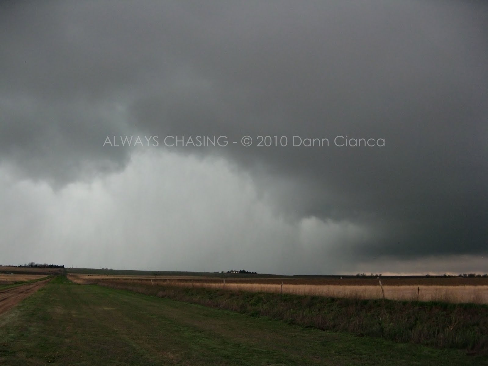
As we continued on south in Bent County, we began to encounter precipitation. It was light rain at first, but as we approached US 50, we were in hail, the size of which was increasing.
 Base Reflectivity (KPUX) and our position in pink at 1903Z.
The precipitation wasn't thick enough to obscure our vision, so we saw the wall cloud start to form while we were still a few miles north of US 50. Reaching the highway, we had a pretty good view, so we pulled off on the shoulder less than a half mile from the intersection of our paved route from the north. I sat there wide-eyed, as the wall cloud began to tighten and a funnel began to form. I decided to report the situation to Pueblo and as I was dialing, I noticed debris getting kicked up under the funnel. It was only 1905Z and we were already seeing our first tornado of the day. It would not be our last.
 Base velocity at 1912Z.
The storm was already severe-warned for hail, but after a couple of minutes and with our report relayed, the tornado warning was issued. We watched the tornado (not fully condensed at this point) skipping across open terrain about 2ESE Las Animas Junction or 2SSW For Lyon (Veterans Hospital). If anything, it was moving a bit to the east as it continued north toward us on the highway. I was taking pictures and video out of my window while Scott ran around and sat in the back seat behind me to do the same.


Unfortunately for us, we were fairly deep in precipitation, so we had to document from inside of the vehicle. Since I didn't have a tripod to set my video camera on, I made the biggest mistake of the day. (At some point, I'll be able to get my video up from the day, but as of now I don't have a decent way to edit the HD material in a way that I want... so it'll come in the future) As I watched a second wall cloud wrap around the first and a second tornado touch down (1t 1911Z), I wanted to get some stills, so I put my video camera in my lap and took a shot with my point-and-shoot.

Unfortunately, when I put my camera in my lap, I didn't hit "stop" and when I brought it back up to continue filming, I immediately hit the button again, which essentially stopped the recording. So, the next five awesome minutes of video will have to be relayed via this report from my memory as it is lost to history.
Please get your imagination ready:
Due to the heavy precipitation and the tornado's approach of our location on the highway, Scott evacuated the back seat and prepared to drive us out of there. Luckily, I would still be able to film since he had to drive (sigh). I watched in astounded delight as the two tornadoes began to rotate around each other, seeming to dance. Hail began to pound the vehicle as we slowly made our way to the east on US 50. Some of the hail on the highway was baseball-sized and a few large stones dented Scott's hood. I held my inactive camera out the window as we got out of the tornado's path and watched the two tornadoes twist around each other and then eventually rope and dissipate.
If you want to see some incredible from a much more DRY perspective (to the east), check out Michael Carlson's video here:
SERIOUSLY, YOU NEED TO WATCH THISAfter the storm passed to the north of 50, we ran into Tim again and chatted with him a bit about how awesome the tornadoes were. The storm was rapidly pressing to the north at this point and we were low on fuel. So, we headed on into Lamar to fuel up. I didn't expect much to happen to the north as the storms pushed deep into the cool but moist air north of the front, so I was all about heading across the border into Kansas where storms were already starting to fire.
We were quite happy that we had scored locally and had not made the trip to Texas. Very happy indeed! As we moved east on 50 toward Kansas, we passed through a couple of cells which had previously dropped their warnings. This was a little disconcerting, but I wanted to stick to the forecast and continue east. To our northwest, our original tornadic cell was still warned and still producing tornadoes! It was hard not to second-guess our decision-making at times like this, but we really couldn't catch it anyway, so it was eastward-the-wagons.
Soon, a newly severe-warned cell was exhibiting signs of rotation as it pressed north, near Ulysses, Kansas. As we began to taste its outer fringes, the couplet strengthened significantly. There was some worry that we were not going to be in a good place but I assured Scott we'd make it through well ahead of the couplet and he trusted me and soldiered on through.
As we emerged from the precipitation, we slipped south a mile or so on a dirt road to get a better look. We were approached by a local who seemed none-too-thrilled with our presence. "Can I HELP you?" we were asked in a "why are you here" tone. We were on a main county road, so it wasn't like we were trespassing, but we decided to move along anyway and headed into Lakin.
Just south of the town, we were able to get a good look at the structure of the storm. I could see a fairly stout RFD core and then something else... it wasn't precip, but it looked like the base of the storm was on the ground. Soon, a report of a "mile-wide tornado" came across Spotter Network, so we had to go get a closer look. We drove through Lakin and headed back west on 50, keeping ourselves about a half mile from the precip core.


As my eyes adjusted, I realized that lurking in the core was a large tornado. I don't know if it was a mile wide, but it was a big fat wedge for sure.

 Hartland EF-2
 Base Velocity at 2156Z
The tornado quickly began shrouded in the precip as it continued to wrap around, now over the highway. We tried to get a little closer, but the RFD was howling across the road in front of us, keeping the tornado shrouded. We decided to head back to Lakin and get on the state highway 25 north to stay ahead of it. Unfortunately, we never did see it again.

We were a couple miles north of Lakin and realized that the storm was going to cross the state highway and that we would either have to progress east on dirt or go back south to get on 50 to stay ahead of it. We opted for the latter. On 50, we proceeded east to Deerfield where we found a reasonable road and headed about five miles north and then another mile back east to have a look. The area was rather low on contrast but we did our best to see what was going on.

After a few minutes, it appeared as if we were watching a distant tornado touch down. After a few seconds, we realized our eyes were not deceiving us! I have very crappy video of this tornado as I didn't have my focus set right and for whatever reason was shaking like crazy in the wind, but here's a screen shot of this tornado, which we call the "Deerfield Tornado". It was actually about 5 miles northwest of Deerfield. Near the end of my video, I remembered to check to see if I was recording, which I was. Unfortunately, Scott was not. The two of us are very paranoid now... always checking for the little red dot.
 Screen shot of my video showing the distant "Deerfield" tornado. This was confirmed by other chasers in the area including Michael O'Keeffe
 Velocity data at the time.
We repositioned a bit north and watched the storm try to produce again, but it couldn't quite get its act together.


We decided to avoid the temptation to travel on dirt roads at this time and retreated back down to US 50. We planned to make our next intercept on US 83 south of Scott City. Unfortunately, this would lead us away from the storm for a while. For about 45 minutes, we basically lost a good visual on the storm as we navigated through the northwest side of Garden City and then north on US 83. The storm was still warned throughout this time with an occasional tornado being reported. We finally made contact again once in Scott County. I believe we made two excursions off of the highway onto county roads to take a closer look. Both times, strong rotation was evident, but it appeared mostly that the inflow was wrapping behind the RFD core, which seemed to be becoming more prominent. Another intercept west of Shallow Water yielded the same results.
As we approached Scott City on 83, the storm was finally looking to head over the highway. A mile or two south of the city, we pulled along side the road near where
TWISTEX operations were taking place. To our south, the RFD was pulsing over the road, but the rain was wrapping around rapidly... almost violently from east to west. The couplet was still very strong at this point and I was worried that there was a large tornado hiding behind the RFD curtain. As it reached us, I think we both came to the realization that it was time to go, especially when we turned around and realized no one else was still there.
We rolled into Scott City to find it deserted and under the eerie howl of the tornado sirens. The city had a lot of water on the streets but we didn't see another vehicle on the road. This was very strange as there were chasers all over the place not five minutes prior. Because we were in precipitation in the town, our visibility was not that great. I could see rapidly moving clouds overhead along with the precip, but that was about it. We turned on Kansas 96 eastbound and Scott gunned it. We were in some heavy precipitation and decent wind for a while, but then light came from behind us and it seemed that we were in a relatively dry RFD cut. Suddenly, barely to the south of the highway, I watched a rapid rotation in the clouds above. Though the rotation was rapid, it was not concentrated. Scott pulled off to the side of the road where we met a wet and frightened dog. We just sat there for a few minutes in awe as a carousel of clouds crossed the road right in front of us. The wind then shifted and rain began to wrap back around from behind us. We pulled forward a bit so that the "open carousel" circulation was directly north of us and prepared to get slammed with RFD, but that never really happened. Eventually, the circulation disappeared into the ether to the north and we found ourselves having difficulty picking out any structure. Even on radar, the storm looked to weaken.
A few miles east, we pulled off the highway between Grigston and Amy. We were fairly pleased with our results for the day... and by pleased, I mean excited! Another chaser pulled off here as well and we were thinking about leaving, so Scott flipped around but the right front tire started to sink through the soft berm of the road. We didn't want to end up in the ditch, so I hopped out and planted my feet, telling Scott to punch it (and hoping that the entire vehicle didn't roll into the ditch on top of me!). Luckily, my horizontal force pushed the vehicle right and we were stable again.
Suddenly, Scott's phone rings and it's his mom claiming that she just watched me push him out of the mud, streaming live on the internet. Sure enough, the other chaser was pointing right at us! So, we went and introduced ourselves to Mr. Randy Denzer and had a good laugh. We chatted with him for a few minutes and took a few pictures before we were on our way.


What boggles my mind is that later on, I would see a video that Randy posted showing a tornado and the sky looking precisely as it was while we were talking to him. Check out the video
here (starting at 3:18 in). He said this happened after we left and since it was off to the southwest, I figure that it had to be a second cell which had formed behind, but in the same line as the first cyclic tornado-maker. I do feel stupid that we missed it. We probably only had to look behind us as we were heading east on KS 96 into Dighton.
We were thinking steak... I think that's what it was. Unfortunately, it seemed that the entire town of Dighton had shut down for the evening. We decided to head up to I-70, try our luck there and maybe get another intercept of the storms which were still heading off to the northeast. We ran into TWISTEX again near Shields and stopped to say hello, accidentally interrupting a Tim Samaras interview with our shenanigans. We chatted with
Tony Laubach and Ed Grubb for a bit and while Tony saw some tornado action that day, he didn't seem too pleased.
When we left, we tried to head north on KS 23 to Grainfield, but the highway was closed for construction. At that moment, the nearby storm appeared to have a nice lowering on it, so I tried to film that for a while but it didn't come out very good as it was almost pitch black out aside from the lightning.
Our detour took us west on KS 4 and we got into a deep hail core that had almost zero visibility. It wasn't that the hail was overly large, but the quantity was extreme. The racket that it made as it pounded the vehicle was absolutely cacophonous. Scott couldn't see at all and wound up on the wrong side of the road. We just took our time out of the core, eventually making it back to US 83 and turning north with the raging thunderstorm lightning to our east keeping things interesting.
Neither of us had had a meal all day aside from a bagel many hours before so as we reached I-70, we prayed to find a place open. We were wanting steak but that soon became an unattainable goal. We ended up at the Sonic in Colby, which was seemingly the only open restaurant of any sort anywhere in northwestern Kansas. I will tell you, however, that the meal at Sonic was amazing. Was it anything special? Probably not... but after not having eaten all day, it was divine.
From there, it was on home to Denver with a full wind in our sails. Not only had we seen tornadoes that day, but both of our targets had verified. Sure, if we would have stayed in Colorado, we probably would have witnessed a few more tornadoes, but for some reason, being able to be a part of both storms ranks up there as a seriously legitimate verification. Dual-target verification!! I still get pumped up when I think about it.
I want to take a moment to reflect on a couple of things.
1) I mistakenly thought that the Colorado storms would die after they crossed the boundary, but in reality, the low level winds were even more conducive for tornadoes and while the temperatures were cooler, the air was very moist. There were a lot of tornadoes north of the boundary!
2) What an incredible storm the Lakin-Scott City supercell was! Throughout its life cycle, it maintained a very strong couplet with multiple mesocyclonic circulations wrapping in and continuously producing tornadoes. We missed several of these but did see two, including the EF-2 Hartland wedge. A second supercell that formed on its heels eventually caught up with the first and they seemed to merge eventually north of Dighton. Awesome storm!
3) Our positioning on the Kansas storm could have been better. After pouring over others video of some of the tornadoes that we missed and even our own experiences with the storm, it appeared that a better observation point may have actually been the back side of the storm where many of the tornadoes were accompanied by a decent and continuous clear slot. Most of the time, we seemed hampered by wet RFD wrapping back into the main circulation.
I definitely feel that while this was a successful chase, I learned a lot of important lessons, including but not limited to: MAKE SURE YOU ARE RECORDING!
STATSMileage: 770
(Year-to-date): 4596
Largest Hail: 2.75"
Other: Strong RFD winds, minor flooding in Scott City.
Tornadoes: 4
1)Fort Lyon I EF-0 - 1905Z Bent County, Colorado - 2ESE Las Animas Junction
2)Fort Lyon II EF-0 - 1911Z Bent County, Colorado - 1S Fort Lyon Veterans Hospital
3)Hartland EF-2 - 2150Z(possibly much earlier) Kearny County, Kansas - near Hartland
4)Deerfield (not rated) - 2234Z Kearny County, Kansas - 5NW Deerfield
Other reports on the date:
Scott HammelMichael CarlsonTim StoeckleinScott BlairJohn & Michael O'KeeffeNWS PuebloNWS Dodge CityOfficial Storm Reports for April 22nd.
VIDEO TO BE ADDED AT A LATER DATE
You can watch Scott's video from the day here:
http://www.youtube.com/watch?v=xeh_bGMf-G0Detail Map:

Dann.