Saturday, April 23, 2011

2011 - March 1st - Lower Flume Creek Canyon, McInnis Canyons National Conservation Area/Black Ridge Canyons Wilderness

It was a cloudy day and I wasn't too excited about photographic opportunities, but I really wanted to get out and go for a hike, so I decided to explore a new area. Someone told me I should checkout the McInnis National Conservation Area trailheads along Horsethief Road southwest of Fruita.

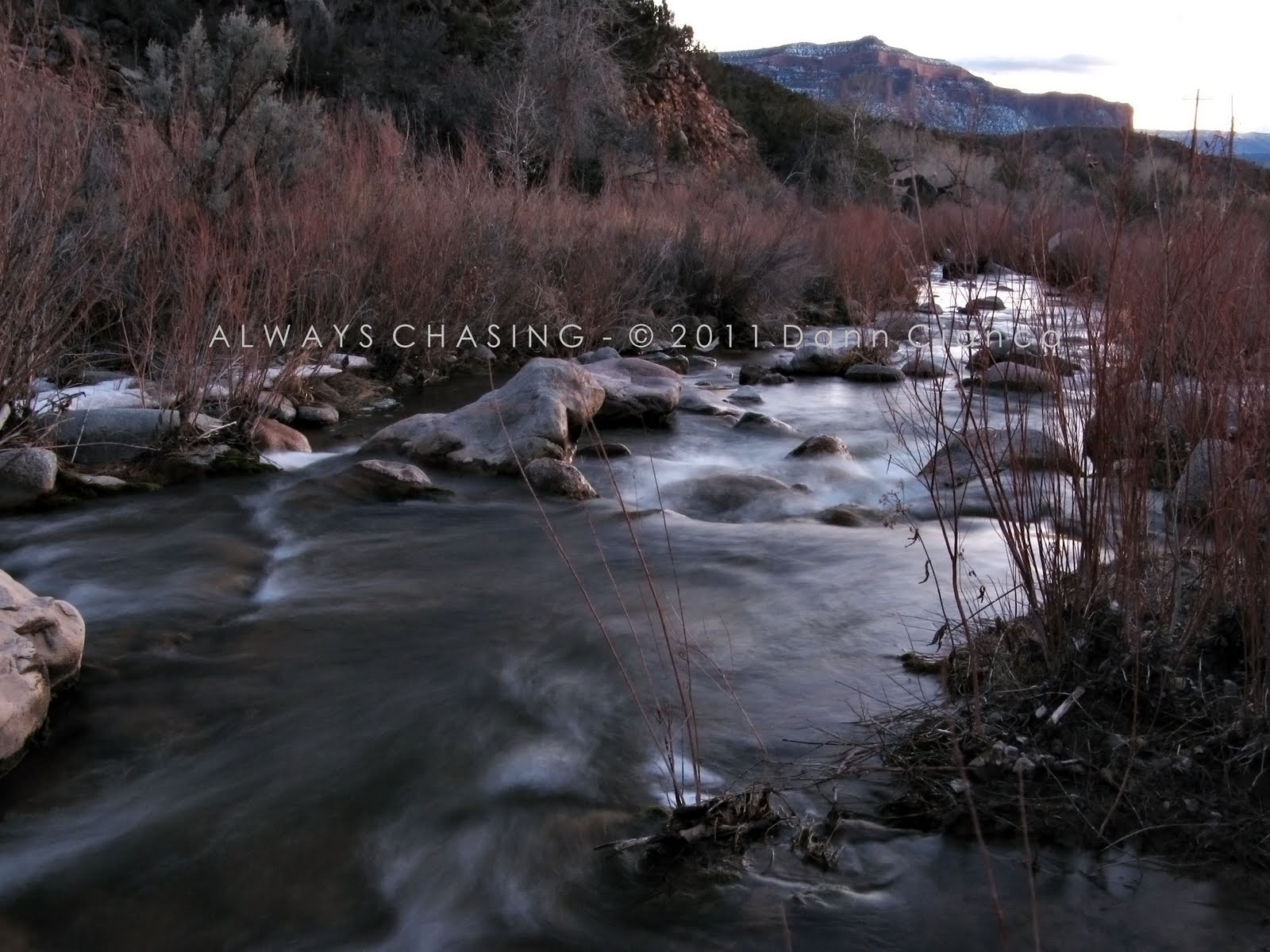
The sun was already getting low in the sky as I arrived in the area and I drove to the end of the road which entered private land. Upon turning around, I stopped at the first available trailhead, intent on stretching my legs and exploring for an hour or so. I chose the Pollock Bench Trailhead and decided I wanted to stay low, along the drainage, instead of climbing up onto the bench. I stuck to the Flume Creek trail which occasionally crossed the weeping stream which was not flowing in all areas. Shortly after the trailhead, I crossed the boundary into the Black Ridge Canyons Wilderness.

The trail eventually climbs a bit away from the stream, but on a short bench, I looked the east and noticed that the stream had carved a tight chasm into the landscape. I walked down to the edge of the chasm which was deeper than it was wide and used a tree to help scale down the vertical wall.

There was a small amount of water flowing through this portion of the drainage and I followed the tight twists and turns of this slot canyon. Eventually, I came upon a scalable drop which was dripping into a sandy sieve. The creek bed above returned to a more comparable elevation to the surrounding terrain.

Above the "Falls"

Sandstone wall detail.

Yucca

I continued up the mostly dry wash from here, trying to make as much ground as I could given the clock ticking toward my turnaround time. Unfortunately, the terrain kept becoming more interesting with layered sandstone looking like offset pancakes forming the bottom of the stream bed, sometimes wet and sometimes not.


Eventually, I found myself in another slot canyon and treading into overtime as far as a turnaround was concerned. Realizing that I hadn't packed the flashlight that I had previously planned on including in my gear, I eventually turned around. I stopped to take a couple of photos of the tight, slot canyon while working on a bag of cajun trail mix.


I rapidly worked my way back down the canyon as it was becoming difficult to see. I left the stream bed at the "falls" as the originally trail joined there. I was unsure as to whether the slot canyon farther down was passable. By the time I approached the trailhead, the waning light in combination with the cloudcover made it extremely difficult to see where I was going.

I did make it back to my vehicle without incident, however, promising myself to pack the flashlight in the future. It was good to get out and hike though the light left me unsatisfied.

Dann.
Next Post: Echo/No Thoroughfare Canyons, Colorado National Monument

Saturday, April 16, 2011

2011 - February 25th - Grand Mesa Winter Storm

I was working on a story at work that required some good snow footage, so I decided to head up to Grand Mesa during a nice winter storm warning. While I didn't make it all the way to the top of the mesa due to personally-administered time constraints, I was able to get some good views in.

The weather was actually quite nice in the valley and even on the drive until I reached Powderhorn, then it began to snow... and the rate of precipitation increased as I ascended the switchbacks on the north side of the mesa.

Anyway, here are a few shots I took while out. Captions as necessary.


This one is my favorite.


Snow on the distant Roan Cliffs with light coming into the Plateau Valley in front of them.

Chalk Mountain catching late-day sun through the snow.


Dann.
PS: I don't really consider this a "storm chase", even though my definition is to "deviate from one's path to pursue a storm" I try to keep it convective.
Next Post: Lower Flume Creek Canyon, McInnis Canyons National Conservation Area/Black Ridge Canyons Wilderness

Thursday, April 14, 2011

2011 - February 23rd - Old U.S. Highway 6

Still slightly concussed from basketball, I spent another day off not doing anything strenuous. However, I really wanted to hike and that restlessness caused me to take another drive. I'm not exactly sure what I was looking for, though I would say it had something to do with a pretty sunset, but I guess I just wanted to do a little exploration.

On this evening, I decided to stay off the freeway. I took the "old highway" (as we would call it in Montana) through Fruita, Loma and Mack. Maintenance is not a priority west of Mack and the road was mostly deserted.


After the state line, the road is not maintained at all. It is mostly dirt with patches of pavement. Even a bridge has a sign that requires large vehicles to bypass it, with a dirt road diving down into the wash. I tried the bridge and the bypass just for fun.

The road eventually meets back up with Interstate 70 and I was ready to head home. However, looking south, I noticed that a few showers had fired up over the La Sal Mountains in Utah as well as the Uncompahgre Plateau.

I thought I might try and get a good shot of the showers as the fading sunlight was beginning to light them. As I drove the Harley Dome road toward Westwater (on the Colorado River), the showers turned bright red. With power lines in my foreground, I got picky and decided to try and get a better angle.

Well, that didn't exactly work out. The road kept going farther down into a gully and I never did get a view of the mountains again. We'll call this one a failure on my part.

I reached Westwater and got out for a moment to listen to the river flowing nearby and then headed back home.

It was a nice drive but I was a little frustrated that I got picky with my shot and didn't take advantage of a nice opportunity.

Dann.
NextPost: Grand Mesa Winter Storm

Sunday, April 10, 2011

2011 - February 22nd - Unaweep Canyon & Gateway Area, Colorado

I have spent a lot of my days off since moving to Grand Junction hiking. That is precisely what I planned to do on this particular day until I injured myself the night before playing basketball. I thought it would be fun to do a half-twist in the air and land on the back of my shoulders with my head whipping into the court. I can still hear the cracking noise echoing through my head. Fortunately, aside from a headache and a little bit of nausea, I was all right. I didn't seek medical help at all, but I'm assuming I had a mild concussion. I decided to take it easy over my "weekend" and not doing anything too physical.

Of course, I became restless and wanted to explore. This gave me a good excuse to go on a drive, even with high gas prices. I figured it was all right to explore a little. I decided to take the Unaweep-Tabegauche (pronounced You-Na-Weep - Tabe-Watch) Byway to Gateway, Colorado. The road follows Unaweep Canyon, which may be a misnomer because the canyon has a natural watershed divide in its middle. There is both an East Creek and West Creek that flow through its steep sided gorge.

The sun was getting low in the sky as I set out and I was hoping for some good low-angle sunlight on canyon walls pictures. I had heard from various people at work that the Gateway area was gorgeous, but I was honestly unprepared. But, I'm getting ahead of myself.

The road, Colorado 141 departs US50 at Whitewater and crosses the Gunnison River. It follows East Creek closely, twisting and turning at times along the shallow lower canyon. Eventually, with a decent amount of elevation gain, the road crosses higher-altitude meadows lined by steep canyon walls. It also widens out here. Near the divide, the meadows still had a lot of snow-cover and ponds of melt-water.

Guarding the canyon like a sentinel just west of the divide is Thimble Rock Point. I decided to get on its light side before taking any pictures and was pleasantly surprised to find a small, derelict mansion for a foreground.


Farther westward, the canyon tightens up again for a while before ejecting out to the a wider valley. Here, East Creek and the Unaweep Canyon meets the Dolores River, along with John Brown Canyon and Lumsden Canyon.

The town of Gateway is very small, with only a few residences and businesses, along with the new Gateway Canyons Resort which spralls on the western side of the Dolores River. The resort is tastefully done, from what I could see, but it is larger than the town.

It was from this side of the river that I stepped out of my vehicle and marveled at the surroundings. Four canyons all come together at one point with a fifth draining the confluence. Sandstone walls and palisades tower over the area making you feel very, very small. It's incredible.

I spent a few minutes taking pictures upstream into the Dolores Canyon...


Looking back up into Unaweep Canyon

...and somehow, I had failed to notice what is known as "The Palisade" looming behind me.


I was absolutely spellbound. The way the evening sun hit the sandstone, the deep blue sky, the altocumulus field and even the unique geology of the formation, it all captivated me. I drove around the area for a while, trying different perspectives.


Dolores River


As the light was beginning to fade, I decided to head back south along 141 (It "elbows" at Gateway, coming in from the east-northeast and then leaves south-southeast) up the Dolores River Canyoon.


I only made it four or five miles south before I had to stop and take it all in. The winding river was gorgeous set against the deep red glow of the surrounding canyon walls. I tried desperately to get good exposures with my point-and-shoot camera and wasn't totally displeased with how they came out.


Once the sun had set, I returned to Gateway but didn't linger. I headed back on 141 into the Unaweep Canyon, before it began to narrow. With the road's proximity to West Creek, I thought I might be able to take some low-light water shots.

I crawled through a few obstacles and found myself alongside the creek where I took some photos.


Light got pretty low, so I returned to Der Schploder and headed into the canyon. On a whim, I pulled into a picnic area a few miles up the road and climbed a wooden fence (there was a gate but in the darkness, I was unable to manipulate it) and cracked off a few more shots. (Still on West Creek)


I was very pleased with these shots, though they came out a bit noisy with my point-and-shoot. Have to work with what I have, though!

Anyway, the rest of the trip back was dark, so I didn't stop anymore. I did almost miss a corner in the tight lower canyon on the East Side, but almost was as close as I got.

All in all, I'm very happy with the images and very happy with my exploration to Gateway. I will be back.

Dann.
NextPost: Old Highway 6 To Utah

Friday, April 08, 2011

2011 - February 17th - Blue Mesa Reservoir/Dillon Pinnacles, Curecanti National Recreation Area

I was heading out to Gunnison for work to do a report on weather modification. Our chief photog/videographer suggested I bring my camera along and it turned out to be very fortuitous.

While I didn't have any time to linger around and take pictures, we stopped to stretch our legs on the way out and once on the way back, both along Blue Mesa Reservoir. It was a windy day and while some parts of the state were seeing snow, we were in full sunshine.


On the way back, we stopped at a fantastic pullout and view of the Dillon Pinnacles, which looked amazing with early afternoon light.


This one is my favorite. Click for the larger view.


It's always good to have that camera ready!

Dann.
Next Post: Unaweep-Tabegauche Byway/Gateway