Sunday, June 28, 2009

2009 Storm Chase XXVII Report - June 28th - Mountain Supercell

I wasn't going to go out today ... I wasn't going to go out today ... that's what I was repeating to myself as I left my apartment early this afternoon. I knew we'd see a few storms over the Palmer Divide today, but what caught my interest was a weak DCVZ (Denver Convergence & Vorticity Zone) with a couple little circulations on either side of I-70.

I decided to target the south end of the boundary where the terrain forcing was better. Plus, there were already storms westward from the south side of the Palmer Divide. As I drove south through Parker, I noticed the storm northwest of Colorado Springs was intensifying rapidly. I had planned on sitting in Franktown but soon decided to intercept this storm. Moments after I made this decision, the storm became tornado warned. Here is a radar image of about that time.


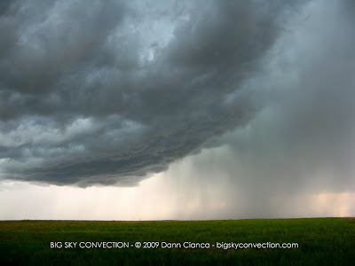
The terrain was rather hilly so I only got occasional peeks, but I was able to see the wall cloud and at the crest of a hill, I stopped to briefly observe the storm. (Pikes Peak is visible behind the base)


The storm began to right-move into Colorado Springs and I began to doubt whether I'd be able to keep position on it through the urban area. I made the decision to head east into the Black Forest area and then south, cutting down the east side of the city. As I did this however, I saw rotation on a weak storm base near my position. Eventually it actually turned into a wall cloud. It had to be elevated, however, as I remained in outflow from the original storm the entire time. The vertical motion on the storm-side of the wall was actually pretty impressive, though the rotation in it was weak.


Eventually, the forward flank of this newly embedded supercell swept around and I found myself behind its FFD gust front (observing a pretty whale's mouth).


I drove south on Meridian Road and then east out of Falcon. The entire complex of storms was rapidly becoming completely outflow, though I did witness another area of rotation just behind me.


The storms weakened and I resolved myself to coring the deepest portion near Calhan, but it only gave me rain. It was time to head back toward Denver at this point, but as I rose over the Palmer, I could see the DCVZ actually firing cumulus. On Colorado 86, I turned briefly for a nice rainbow before continuing.


I went north out of Kiowa to keep en eye on the towers popping, but they never really amounted to much. After fooling around on dirt roads in the middle of nowhere, I decided to call it and head home.


Chase facts:
Mileage: 217
Hail: None
Wind: Est. 45-50mph
Other phenomena: Rainbow, shelf cloud, wall cloud.
Other chasers: Tony Laubach


Dann.

Saturday, June 27, 2009

2009 Storm Chase XXVI Report - June 26th - Surfing The Line

Thunderstorms fired over the Metro area around 2PM. I had been keeping my eyes on a boundary oriented west-east over Denver and then stretching off to the northeast, east of town. Though we were capped at the lower levels, the higher terrain was able to get stuff going. Eventually, as I was leaving work at 3PM, the cap broke over the metro, prompting severe warnings. I'm glad the NWS read my mind and eventually warned the "outflow" and not the precip core as it was the wind that was causing chaos.

As per usual, I got caught in traffic on Interstate 225 and watched a wall cloud developing on the departing storm to my east. It didn't help that people were driving like idiots. By the time I was eastbound on I-70, blowing dust made it hard to determine storm structure.

I noticed at this point that I wasn't making much headway on the storm in front of me. I merged onto US 36 and continued due east, trying to keep up with it. Luckily, there wasn't much precip and the fantastic tail wind kept the drive comfortable. I continued eastbound, seemingly racing the blowing dust, periodically watching myself *slowly* catch up to curtains of rain visible on the highway in front of me. That whole experience was very neat.


The boundary kicked up cells in its wake but they never truly organized into an organized linear complex. I would wager this is because the air in front of it was capped. The outflow seemed to travel under the cap (like ducting), though pushing the capped layer a bit higher. Occasionally, a cell would push through but the meager upper level winds wouldn't push it near as quickly as the area before. So, the cells would pulse up and die as the boundary pushed through.

As I blasted into Kansas, I noticed the winds were finally out of the south and not the north or northwest. After almost three hours and starting out less than 10 miles behind the boundary, I had overtaken it. I would estimate that it was traveling at an average of sixty miles per hour.

I stopped in Saint Francis, Kansas for gas and watched the wall of dust approach from the west. It moved back over me by the time I had filled up (guess it didn't have to stop for gas) and I continued to pursue it to the east. I passed it again just before Bird City and had been watching a boundary move into the area from the east. I thought it might slow the pace of the line but it did not. In fact, nothing seemed to happen. I had been banking on that getting something going, so I resolved go start making my way north into the more backed (relatively) surface winds in Nebraska.

Of course the line took me again and I thought to stop and take pictures of the weak shelf cloud, but figured I didn't have much time. The cross winds were pretty intense but there was virtually no precipitation. I continued east after making it to Benkelman and finally decided to call it a day as I approached Trenton, Nebraska. I sat on an overlook at Swanson Reservoir and watched one of the embedded squalls come through.


Though I wanted to head home, I decided to cross the dam and drive around the reservoir on the south side. After the storm passed, I did this and went west on dirt/mud. I found an almost secret road that took me to a bluff overlooking the reservoir. The light in the sky was amazing, so I just sat and reveled in it for a while.


Eventually, I continued west and stopped repeatedly for pictures of the amazing sunset. The bight white high cirrus *almost* looked like noctilucent clouds ... but the contrast with the altoclouds just made it appear that way. It was amazing, either way.


On the way home, it was a bug apocalypse on the windshield for sure. I stopped at Dairy Queen in Yuma, Colorado for dinner ... and dessert. :) Got home around 12:30.

Total mileage: 502 miles (now over 30,000 since I started chasing in 1997!)
Largest hail: none confirmed
Strongest wind: estimated at 70mph (very minor tree damage)
Other phenomena: wall cloud, blowing dust, close lightning, rainbows, sunset


Dann.

Tuesday, June 23, 2009

June 22nd, 2009 Teaser - Tornado-Warned Cell & Lightning

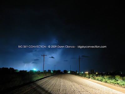
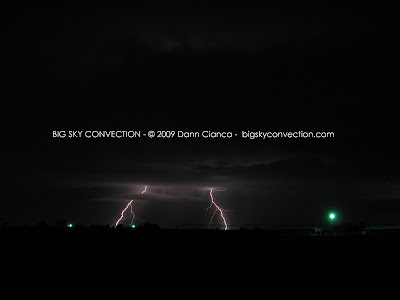
Went on a little impromptu chase tonight. The plan was lightning but the northern storms strengthened and I realized I was within interception distance. I coordinated a bit with Tony Laubach who was ahead of me. He spent time time enjoying the core of the southern, now-severe-warned cell. I danced in and got some (not measured) nickel-sized hail mixed in with the rain. I blasted east toward Greeley and got ahead of it to see some interesting structure. It became tornado-warned at that point (in addition to a northern cell that was also t-warned). I stair-stepped north and east, keeping an eye on things. Saw a brief wall cloud but was in outflow the entire time, so if it was rotating, the inflow was elevated and not surface-based. Ran into a friend, Chris Andersen, north of Gill and stopped to chat and shoot lightning for a while. Here are a few images:


Dann.

Friday, June 19, 2009

June 18th, 2009 Denver Metro Lightning

Well ... went out to shoot a little lightning tonight. There were some great CGs ... and they all happened out of frame or whey my camera said "busy". A bit frustrating ... especially since I was out there for over two hours. Interesting storm structure near the end, though ...


I added more photos earlier today, so make sure to check out the previous post(s) if you haven't already!

DC

Thursday, June 18, 2009

More photos from June 17th

We followed a VERY photogenic supercell as it evolved from a small cumulus puff over Denver all the way into Nebraska. You saw my hail pictures yesterday (which can be found here: GORILLA HAIL!)


Can't wait to get out again!

DC

June 17th, 2009 Chase Teaser - Gorilla Hail!!!

I'm exhausted and I have to be at work in like six hours, so here's a couple photos and a brief description of the day:

No, we didn't see any tornadoes. However, we followed a tiny white cloud that formed over my office in Denver all the way to the Nebraska border where it cycled through very interesting structure and shot out these puppies below. At first, I wasn't sure what the size was ... guessed 3". Well, my phone is 3.75" in length ... AND ... measuring the larger hailstone below (at least estimated, given the photograph), I would pin the bottom one at 4". And we only briefly ran out to grab stones, so it was possible that there were larger.

There is video coming, though not mine.


Chased with Michael and Eric Carlson.

Dann.

Monday, June 15, 2009

June 14th, 2009 Chase Teaser

It's about bed time, so I'll let the pictures speak for themselves. Long chase short, we got out east quick, headed back to Denver to intercept a tornado-warned cell ... decided to stick on one that popped up right on top of us ... had some great structure ... then went outflow bow echo!

We almost went home, but ended up dropping south and intercepting twin supercells, one of which ended up having a huge wall cloud and almost producing a tornado! We continued to follow it with fantastic light conditions ... and well, yeah ... great pictures.


Great structure!


Shelfy in Limon!


Beginning of the beast.


White cone funnel cloud. (just a couple miles south of Punkin Center, CO)


New wall cloud with inflow tail.


Very photogenic wall cloud.


Oh man, we were getting excited!!


Winding down and a look at the mesocyclone.


The hidden beauty of the high plains. (oh, the storm died ... so we were just kind of watching its last throws).


The only unfortunate portion of the day came at the end when I found out that the DVD I had recorded most of the day's festivities on was corrupt. So, I lost all video of the first amazing base (with great CG's), coring the squall line and then another hail core, and the white, cone funnel becoming a big trunk. Hopefully, I'll be able to retrieve the data somehow. Luckily, my chase partners were taking photos and video during the chase, so hopefully not all was lost. I also managed to get a picture of the cone funnel, so at least I have that.

Anyway, great chase day with Michael Carlson and Johnathan Skinner. Can't believe I've already chased 22 times this year. With 4 tornadoes and a little over 12,000 miles, it's been eventful.

DC

Sunday, June 14, 2009

June 13th, 2009 Chase Teaser

Today was a frustrating, but somewhat rewarding day.

My initial target was Pine Bluffs, Wyoming. We headed up to Cheyenne in the late morning and watched storms fire off of the Laramies. We followed one east toward La Grange. This storm was strong but never really became severe, holding a rather consistent strength.


Things weren't turning out as forecast ... I'm not sure why, but I'm thinking there was some trouble with a stable layer. We saw a couple of boundaries and spent all day under the cu field, but nothing explosive really happened.

We abandoned our northern target as storms became strong to severe down in Colorado. As we approached Cheyenne again, we observed strange storm motion and concluded that there was some sort of boundary or mesobeta-cyclone in play. We watched a lowering on a storm just southeast of Cheyenne and decided to punch through its meager core. As we passed through, we watched with delight as a nice mesocyclone and wall cloud spun about. Soon, we realized the precipitation was gone! This thing was all by itself out there, just spinning way ... with rapid inflow and some pretty intense vertical motion. I called the "rapidly rotating wall cloud" in to the Cheyenne NWS and came close to reporting funnels a couple of times, especially as a parcel of descending air punched through the back and wrapped up a brief circulation.


Eventually, we had to let this storm go in favor of the severe/tornadic cells in Colorado. We drove ... rapidly to Kimball, Nebraska and then south on 71 all the way toward Brush. We encountered some flooding north of Snyder which almost sent us off the road.

We intercepted a tornado-warned cell in Fort Morgan, but it looked like outflow garbage the entire time. Finally, as the cell bowed out and kicked up some debris in Brush, we left it in favor of a persistent right-moving supercell down south. We cored it at twilight and came out to see the silhouette of the base. Michael allowed us to get out and have a look. A wall cloud formed, illuminated by the frequent lightning. Here's one shot:


F2.8, ISO 100, 15"


There were a lot of hangy-downies with this wall cloud and parent hooked supe, but we were unable to ascertain any definite funnels given the amount of light present and the rapid movement on the cloud base. There are a few "blurs" on other photos that could be something, but we'll never know!

We watched this storm for a bit and finally decided to head home.


The only reason I say that I was frustrated centered around the fact that my first target didn't pan out and we missed some tornadoes in Colorado.

Oh well, there's always tomorrow.

DC

Friday, June 12, 2009

June 11th, 2009 Storm Chase Teaser (Lightning)

Well, aside from the impressive supercell(s) in the Arkansas River Valley yesterday, things turned out pretty much as I expected them to. I do wish that I would have chased those storms, though. Man, some of the pictures I have seen are quite impressive! Congrats to Verne for pulling the tornado out of the deep core, impressive catch!!

Today was a bit of a surprise as well. I saw the boundary on the south side of the Palmer and didn't think much of it because of the ... I'm ashamed to say this, 45ºF Tds. The old Dann, the one not used to Denver being consistently humid like it's been for the past month, would have slapped me. We saw a nice train of supercells roll on the south side of the Divide today. Gorgeous! Too bad I was at work ...

Anyway, last night I did manage to get out for a severe-warned storm that blew through the Denver area at 11PM. I got some of the best lightning pics that I've ever taken. Enjoy! Click for larger images:


Oh yeah, and I'm chasing on Saturday and Sunday! Bring on the weekend!!!

DC