Thursday, July 31, 2008

Ugh, hot.

Heat Advisory

URGENT - WEATHER MESSAGE
NATIONAL WEATHER SERVICE DENVER CO
355 PM MDT THU JUL 31 2008

...WARMEST TEMPERATURES OF THE SUMMER POSSIBLE ON FRIDAY...

.A PERSISTENT HIGH PRESSURE RIDGE OVER THE SOUTHWESTERN UNITED
STATES WILL PRODUCE VERY WARM TEMPERATURES OVER NORTHEASTERN
COLORADO ON FRIDAY. HIGH TEMPERATURES ARE EXPECTED TO CLIMB ABOVE
100 DEGREES ACROSS MUCH OF NORTHEAST COLORADO.


...HEAT ADVISORY IN EFFECT FROM 1 PM TO 9 PM MDT FRIDAY...

THE NATIONAL WEATHER SERVICE IN DENVER HAS ISSUED A HEAT
ADVISORY...WHICH IS IN EFFECT FROM 1 PM TO 9 PM MDT FRIDAY.

TEMPERATURES ACROSS THE PLAINS FRIDAY ARE EXPECTED TO BE IN THE
LOW AND MID 90S BY EARLY AFTERNOON. READINGS ARE THEN EXPECTED TO
PEAK BETWEEN 100 AND 105 DEGREES IN THE MID AFTERNOON. THE MERCURY
WILL PROBABLY REMAIN ABOVE THE 90 DEGREE LEVEL UNTIL MID-EVENING.

A HEAT ADVISORY MEANS THAT A PERIOD OF HOT TEMPERATURES IS EXPECTED.
SUNNY SKIES...HOT TEMPERATURES AND LOW RELATIVE HUMIDITIES WILL
COMBINE TO CREATE A SITUATION IN WHICH HEAT ILLNESSES ARE
POSSIBLE. DRINK PLENTY OF FLUIDS...STAY IN AN AIR-CONDITIONED
ROOM...STAY OUT OF THE SUN...AND CHECK UP ON RELATIVES AND
NEIGHBORS.

$$
DANKERS


Dann.

Record Event

The temperature at Denver International Airport has just reached 90ºF, making it the 19th day in a row that KDEN has seen 90ºF+. This breaks the record of 18 days.

Forecast (NWS) highs for the next six days.

Friday: 102º
Saturday: 99º
Sunday: 101º
Monday: 97º
Tuesday: 93º
Wednesday: 89º

My sincerest apologies to my parents, who are driving down from Montana on Friday to help me move to a new apartment.

Dann.

A Look At The Heavens

The Milky Way

Dann.

Wednesday, July 30, 2008

20080730 Wx Discussion I (1517Z)

COLORADO WEATHER

Denver looks to tie its 18-days-in-a-row 90ºF+ record today. With a huge ridge in place, there's no reason to believe the record won't be tied, broken, and ultimately shattered. It's going to be hot.


MONTANA WEATHER

High wind and low humidity has given cause for the weather service to issue Wind Advisories and Red Flag Warnings for much of Western Montana.

URGENT - WEATHER MESSAGE
NATIONAL WEATHER SERVICE MISSOULA MT
737 AM MDT WED JUL 30 2008

.SURFACE PRESSURE GRADIENTS WILL TIGHTEN CONSIDERABLY OVER
WESTERN MONTANA TODAY. WINDS WILL INCREASE THROUGH THE DAY AND
BECOME GUSTY BY AFTERNOON AS UPPER LEVEL WINDS ARE TRANSPORTED
DOWN TO THE SURFACE. PRESSURE GRADIENTS WILL QUICKLY WEAKEN THIS
EVENING AROUND SUNSET AND WINDS WILL DIMINISH.

MTZ007-310200-
/O.CON.KMSO.WI.Y.0013.080730T1800Z-080731T0300Z/
BUTTE/BLACKFOOT REGION-
737 AM MDT WED JUL 30 2008

...WIND ADVISORY REMAINS IN EFFECT FROM NOON TODAY TO 9 PM MDT
THIS EVENING..

A WIND ADVISORY REMAINS IN EFFECT FROM NOON TODAY TO 9 PM MDT
THIS EVENING.

SUSTAINED WESTERLY WINDS OF 20 TO 30 MPH WITH GUSTS TO 40 MPH ARE
EXPECTED FROM EARLY THIS AFTERNOON THROUGH 9 PM THIS EVENING.
LOCALIZED WIND GUSTS TO IN EXCESS OF 50 MPH WILL BE POSSIBLE NEAR
MCDONALD PASS AND NEAR DEER LODGE AND ANACONDA.

A WIND ADVISORY MEANS THAT STRONG WINDS ARE EXPECTED. DRIVING MAY
BE DIFFICULT...ESPECIALLY FOR HIGH PROFILE VEHICLES...SO USE
EXTRA CAUTION.
-----

RED FLAG WARNING
NATIONAL WEATHER SERVICE MISSOULA MT
824 AM MDT WED JUL 30 2008

MTZ110-111-310300-
/O.NEW.KMSO.FW.W.0002.080730T1800Z-080731T0300Z/
DEERLODGE/WEST BEAVERHEAD-EAST BEAVERHEAD-
824 AM MDT WED JUL 30 2008

...RED FLAG WARNING IN EFFECT FROM NOON TODAY TO 9 PM MDT THIS
EVENING FOR GUSTY WINDS AND LOW HUMIDITIES ACROSS THE
DEERLODGE/WEST BEAVERHEAD...EAST BEAVERHEAD..

THE NATIONAL WEATHER SERVICE IN MISSOULA HAS ISSUED A RED FLAG
WARNING...WHICH IS IN EFFECT FROM NOON TODAY TO 9 PM MDT THIS
EVENING.

SUSTAINED WEST TO NORTHWEST WINDS 15-20 MPH WITH PERSISTENT GUSTS
OF 20-30 MPH...LOCALLY UP TO 40 MPH...ARE EXPECTED THIS AFTERNOON
AND EARLY EVENING. THESE WINDS COMBINED WITH LOW RELATIVE HUMIDITIES
OF 10-15% THIS AFTERNOON WILL PRODUCE RED FLAG CONDITIONS.


A RED FLAG WARNING MEANS THAT CRITICAL FIRE WEATHER CONDITIONS
ARE EITHER OCCURRING NOW...OR WILL SHORTLY. A COMBINATION OF
STRONG WINDS...LOW RELATIVE HUMIDITY...AND WARM TEMPERATURES WILL
CREATE EXPLOSIVE FIRE GROWTH POTENTIAL.

$$


Dann.

Saturday, July 26, 2008

Awesome


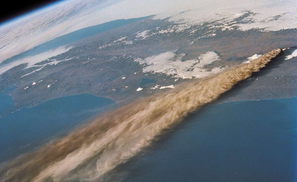
Credit: Science and Analysis Laboratory, NASA-Johnson Space Center
Russia's Kliuchevskoi Volcano, seen erupting from 115 nautical miles above Earth on September 30, 1994. Astronauts aboard the Space Shuttle Endeavour captured this image of the Earth's limb, and Kliuchevskoi's ash plume spreading out across the Pacific Ocean.

Friday, July 11, 2008

20080712 WxDiscussion I (0142Z)

MONTANA Weather

Record lows expected in some low-lying areas of Western Montana early Saturday morning. It would be a good time to cover your flowers or bring them indoors! Butte could see the mid-20's, though I suspsect it won't go much lower than 30ºF. Still, that's enough to frost your flowers and produce.

Dann.

Wednesday, July 09, 2008

20080710 WxDiscussion I (0410Z)

MONTANA WEATHER

The National Weather Service in Missoula has issued a High Wind Warning for part of western Montana:

BUTTE/BLACKFOOT REGION-
227 PM MDT WED JUL 9 2008

...HIGH WIND WARNING IN EFFECT FROM 12 PM THURSDAY TO MIDNIGHT
MDT THURSDAY NIGHT ABOVE 6000 FEET...

THE NATIONAL WEATHER SERVICE IN MISSOULA HAS ISSUED A HIGH WIND
WARNING ABOVE 6000 FEET...WHICH IS IN EFFECT FROM 12 PM THURSDAY
TO MIDNIGHT MDT THURSDAY NIGHT.

STRONG SUSTAINED WINDS OF 30 TO 40 MPH WITH GUSTS TO 60 MPH CAN BE
EXPECTED THURSDAY ABOVE 6000 FEET. THE HIGHEST GUSTS WILL BE
EXPERIENCED NEAR MCDONALD PASS AND ALONG THE MONTANA HIGHWAY 1
CORRIDOR FROM GEORGETOWN LAKE TO ANACONDA. OTHER LOCATIONS LIKE
PHILIPSBURG AND DEER LODGE CAN EXPECT TO SEE GUSTY WINDS BETWEEN
40 AND 50 MPH.

A HIGH WIND WARNING MEANS A HAZARDOUS HIGH WIND EVENT IS EXPECTED
OR OCCURRING. VERY STRONG WINDS CAN LEAD TO PROPERTY DAMAGE.


COLORADO WEATHER

A rather quiet pattern will exist for the next few days. Ridge in place, moisture gone. Sunday looks interesting though, as an incoming trough will help to advect some moisture into the area. Lift, associated with the trough, will also make things interesting.

Dann.

Friday, July 04, 2008

20080704 WxDiscussion I (1545Z)

MONTANA Weather

Severe weather very likely today in Western Montana. Approaching trough will interact with ridiculous amounts of moisture (ridiculous for this area, anyway... dewpoints between 55F and 65F!!) and thunderstorms will be widespread. Latest RUC run (14Z) is showing up to 4000J/kg of CAPE over the Butte area by this evening! ETANAMWRF is only showing 2000J/kg ... but that's still a lot. Shear profiles are favoring supercells over the less complicated topography. Everything is in place for a major hail/wind event in Western Montana. If supercells develop and persist, tornadoes are not out of the question, though I don't think likely.

I'll try and update a bit later ... but now it's off to the Fourth of July parade ...

PS: Barack Obama is not going to be in the parade as planned ... due to security reasons. haha He'll just be watching.

Dann.

20080703 Butte, MT Fireworks & Thunderstorms (Preview)

It's pretty late and I want to get some sleep tonight, so I'll make this quick. If it wasn't crazy enough here in Butte with Barack Obama being in town, the combinatoin of the city's usual chaotic Third of July and three separate rounds of thunderstorms caused pure pandemonium!

I honestly wasn't expecting any 'weather' until tomorrow. Approaching Butte (from Billings) today with my cousin Brad, I noted that there seemed to be a decent amount of moisture available and towering cumulus was going up in southwest Montana.

After joining my family for some awesome festivities, I began to notice that there were storms on the horizon, likely associated with the approaching wave. Over the next few hours, we experienced three separate rounds of storms, which included heavy rain, pea-sized hail, strong winds, and amazing lightning. In between each round, the revelers would come back out and light up pyrotechnics. Even the big show was delayed ... the night was amazing though.

Here is a sampling of the some 90 images that I took tonight.
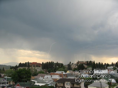
Probably my best ever "daytime" lightning shot.
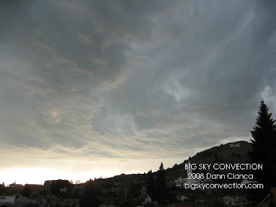
Very neat storm structure. Couldn't quite put itself into an organized cell ... there were multiple updrafts.
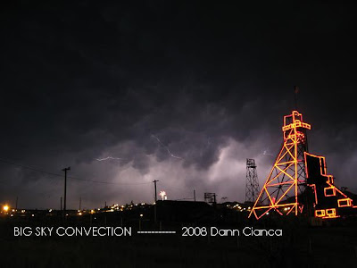

Very, very proud of this shot. Fireworks, lightning, mammatus, great Butte subject matter. This is probably one of my all-time best (favorite) works.
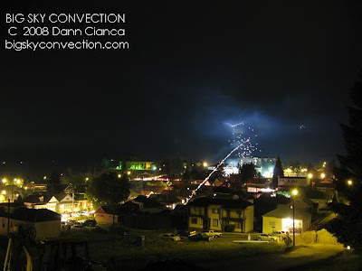

Just another cute little fireworks/lightning shot.

Wow, I'm still in disbelief about tonight. I'm sorry to my family, whom I ignored throughout the evening while taking pictures ... grandma, the ribs were delicious.

... and tomorrow is supposed to be the day for severe weather. I better buy more batteries.

Dann.

PS: None of the above photos were touched up in any way except to put text on them.
Thursday, July 03, 2008

2008 Storm Chase VI - July 2nd (Preview)

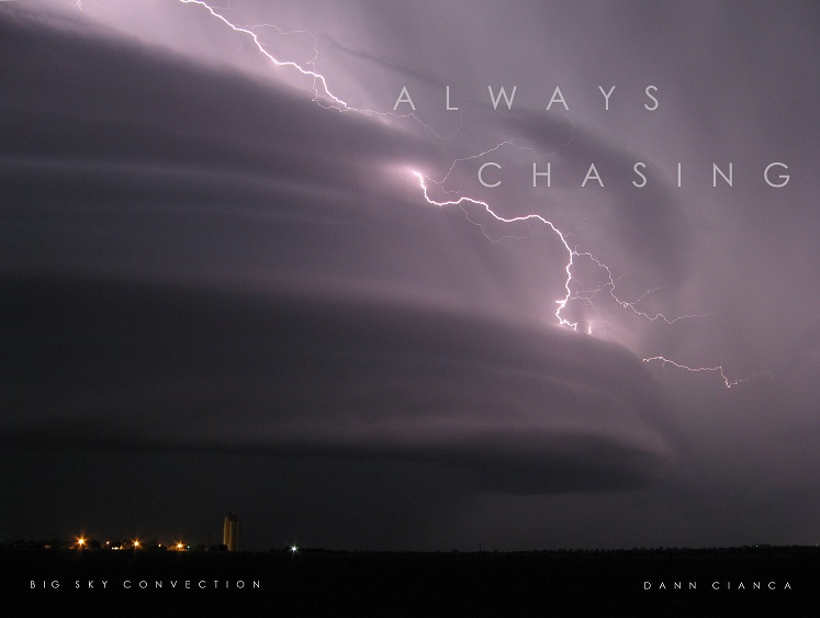
Went out for kind of an impromptu chase with Tony Laubach today. We drifted north to intercept storms firing along the southern 'slopes' of the Cheyenne Ridge. While they didn't necessarily organize into supercells, the storm we intercepted near Wiggins had some beautiful structure.


After "minesweeping" the core of the now line of storms, we decided to follow the storm east. As we were punching into the core a second time, a circulation developed in the line. Traffic on I-76 was horrible, however, and the precipitation made progress slow. Our route took us through Brush, but what we found there made us stay and survey.

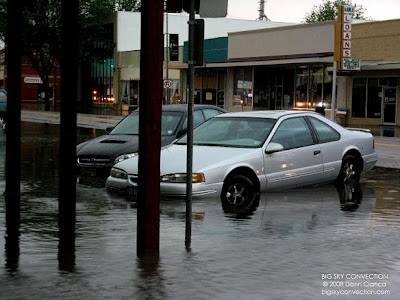
We found that many of the streets in town were under water. Very strong winds associated with the line of storms (which appeared to bulge as it drove through Brush) knocked down large tree branches and several small trees. The streets were littered with tree debris and this possibly clogged the storm drains, preventing the radar-estimated 1.5"-2" of rain from draining away. Luckily, we didn't see any injuries, just a lot of weathered residents standing in their front yards, pulling tree limbs into piles.


I have plenty of video from the chase, but have run out of time to process it. Tony should have his up eventually and I'll try and link it if it's before I get mine up. All in all, very pleased with this chase. Full report coming eventually.

Dann.

Wednesday, July 02, 2008

20080702 Wx Discussion I (1840Z)

COLORADO Weather

"I'm not sure exactly what they're seeing" ... that's what I said yesterday. They must have been seeing something I didn't, because there was a fair coverage of storms yesterday. While none of them ended up leaving much precipitation on the plains, I was surprised at how well convection initiated (even if it was high-based). Oh well, live and learn.

Today, we have much more moisture to work with at the surface. While dewpoints dropped into the low 30's yesterday afternoon, we're still sitting in the mid 40's today. Add in a little upper level support care of a short wave plowing off the Rockies to our north and the weak surface cold front that is in the process of moving through and we have a much better chance for storms today. Most of the models are drying out the metro area in the next few hours, but winds have shifted to a more easterly component which should advect more plains moisture into the area. We'll see which dynamic winds the battle.

Wind shear and support are greater to our north, so if I don't have to work at F2P2 today, I might try and join up with Tony Laubach for an afternoon chase on the north side. We'll see.


MONTANA Weather

FORECAST: July 4th

A storm system will be moving in from the Pacific Northwest, bringing with it plenty of Pacific moisture. GFS and WRF-NAM-ETA all are showing dewpoints in the mid 50's in western Montana on Friday. The southwest corner of the state stays more dry and it looks like we'll see a bit of a quasi-dryline setup, probably banked against a mountain range like the Anaconda Range.

I'll be spending the day along the Big Hole River, near the town of Divide. Minor atmospheric capping will be in place in the morning, but convection should initiate with daytime heating and timing of the upper level support. Models are showing CAPE values up to 2500J/kg!!! I would wager that cumulus will develop progressively NW to SE over the course of the afternoon, with the first radar echoes showing up near 1PM. With the moisture available, steep lapse rates, and decent shear, severe weather is very possible. Hail up to an inch and a half could be possible as well as damaging winds in or around the mountains. I wouldn't rule out the possibility of a tornado in broader valleys where dynamics could really support a lone supercell.

I hope to see some of nature's fireworks along with the man-made pyrotechnics.


Dann.

Yeah, Sure, You Bet ya' ... unbelievable Swedish tornado video!!


... some of the coolest tornado footage I have ever seen.

Dann.

Tuesday, July 01, 2008

20080701 Wx Discussion I (1335Z)

MONTANA Weather

Well, we didn't quite make it yesterday in Butte. The high topped out at 91ºF and would have gone much higher if it weren't for the high clouds associated with nearby thunderstorms. The intense surface heating steepened valley to mountain lapse rates and combined with "generous" amounts of Pacific moisture, made it easy to reach convective temperatures yesterday. Storms fired along the Bitterroots, Pioneers, Centennials, and the Anaconda Range early in the afternoon. The high clouds blanketed most of western Montana and kept the temperatures from going any further.

There were, however, a few record highs set ... especially where the high clouds didn't shade the area:

...METAR STATIONS - WESTERN MONTANA...

NEW PREVIOUS
RECORD RECORD (YEAR SET)

MISSOULA 96 (TIE) 96 (1990)
KALISPELL 94 92 (1944)

...COOPERATIVE OBSERVER STATIONS - WESTERN MONTANA...

NEW PREVIOUS
RECORD RECORD (YEAR SET)

LIBBY 99 (TIE) 99 (2003)
LIBBY 32 SE 87 85 (1950)
POLSON 92 (TIE) 92
SUPERIOR 99 98 (1939)
WEST GLACIER 92 90 (1990)


A friend of mine in Missoula, MT called me concerning a "Tatooine Scale" sand storm around 7:00PM last night. In case you were wondering, this was probably caused by cool (dense) outflow from storms on the south end of the Bitterroot Valley, draining down the valley toward Missoula. Hamilton's winds picked up out of the south at 6PM, with Corvallis and Stevensville soon following. Missoula's wind shifted (from NNW to S) and picked up by 7PM. This seems to verify as there were storms at the south end of the valley at 6PM.


COLORADO Weather

NWS Forecast discussion is calling for storms to develop over the mountains and foothills by noon today. The models (RUC, WRF, GFS) have the entire area mixing out big time during the early afternoon, so I'm not sure exactly what they're seeing. They mention the convective temperature being reached ... but we'll see. The plains will remain stable today unless some convergence zone sets up near or off the Palmer like yesterday. Without any surface moisture, though, I don't think anyone is going to see much rain.

Dann.