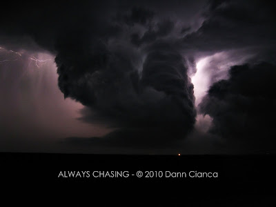
Sunday, June 27, 2010

2010 Storm Chase 26 Brief (June 19th)

The cap never *really* broke all the way. Storms went up and fought with the inhibition and lack of upper level support all day and thus remained subsevere. The highlight of the evening was coming across this abandoned building in Buckingham, Colorado. We eventually followed this cell to Sterling where we had dinner and headed on home.


BONUS PHOTO:

Just messing around in the old house. :)

Dann.

Saturday, June 19, 2010

2010 Storm Chase 25 Brief (June 18th)

Horrendous inhibition all day... possibly broke by convergence on the Denver Cyclone or some upper level lift coming through... haven't had the time to dig in just yet. Knew that the hodos supported supercells if something went up (though the CAPE was rather meager). Anyway, after towers went up and seemed to persist, I hit the road and went out east. The light was amazing... which really set up the fact that every updraft started spinning like a top. I photographed at least 4 supercells with high-based, laminar mesocyclones. Some had multiple mesos.

Night was fantastic until I blew a tire out on I-70 on the way back and then stripped the lug trying to get it off. Somehow, I managed to get leverage on the lug and get it off, but not after spending an hour on the side of the road. I think the pictures were worth it, though.


Dann.
PS: The first photo is of TDEN, the Terminal Doppler Weather Radar (TDWR) for the area.

Saturday, June 12, 2010

2010 Storm Chase 24 Teaser (June 11th)

Another last minute call to head out after work since storms hadn't completely gone out of reach. Intercepted three tornado-warned cells, though none of them produced.


Hail fog near Strasburg, Colroado


Backside of a strong but skinny meso north of Stratton, Colorado


Dann.

Friday, June 11, 2010

2010 Storm Chase 23 Brief (June 10th)

Long story short:

Tonight was frustrating to say the least...

Actually made it out of the city on time to chase the storms. Decided on the southern cell and made an intercept but the base was pretty high.

Mistake #1:
Got distracted by the gargantuan hail. While collecting stones the meso lowered significantly to my east and produced two tornadoes which I was unable to see due to light refraction in the precip.

Mistake #2:
I anticipated the storm to right-move, so against the advice of my nowcaster, Michael Carlson, I decided to go south to cut the storm off, instead of north and then east, through the core. This put me out of position on the storm for almost 45 minutes.

Mistake #3:
AT&T No radar data for TWO AND A HALF HOURS, with half of that being after dark.

Mistake #4:
Not fully charging my phone and not bringing the charger... subsequently running out of juice and losing contact with nowcasters while radar data was down for TWO AND A HALF HOURS.

Mistake #5:
Chasing too far and too long and getting back home really late.


Victories:
1) Gargantuan hail, 3.5" measured.
2314 300 2 NW DEER TRAIL ARAPAHOE CO 3964 10407 HAIL 3.5 INCHES (BOU)
(not sure of why there is a discrepancy between the "size" and the "remark")

2) Decent storm structure, even after dark and being visual on the storm after dark without radar data.

3) Actually being on the storm after getting out of work just before 6PM.

Now, a couple of teaser pics.

GONKS


Mid-level funnel just northeast of Anton.


Amazing structure... A very interesting, almost skeletal view of the back side of the meso. There was a tornado report in the area about five minutes before this photo was taken.


Congrats to all who witnessed and documented tornadoes today.

Dann.

Monday, June 07, 2010

2010 Storm Chase 21 Teaser - June 6th

Meat and potatoes:


Structure early... high bases...


After a lot of minesweeping, we were pretty much done and in Brush, watching the storms depart. Popped off this shot with my trigger finger.


Storm popped up right over us and dropped some golf balls! (If you're unfamiliar with the coinage, that's the "Eisenhower Dollar", which is 1.5" in diameter. The top stone was bigger by a quarter of an inch.)


Took a few more structure, hail, sunset, late-night structure shots, but yeah, if I shared more that would almost be like a whole report, now, wouldn't it!


Dann.

Saturday, June 05, 2010

2010 Storm Chase 20 Teaser - June 5th - Patience Is A Virtue

Went out today and watched the cap hold over the Palmer Divide. Weak storms went up, we pursued, they died. Grabbed some dinner, storms looked better (blame the better lapse rates!) so we saw some color and then headed home. As we were getting back to my place, the light show started, so I headed over to the closest park-and-ride garage and gargoyled it on the top for a good, long while.


Colorful convection east of Denver. (Had to do a short exposure to prevent the top from overexposing).
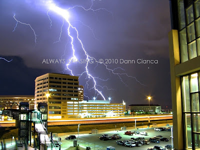

Amazing, close cloud to ground strike from my perch in Greenwood Village (looking west).


As the storm left to the east. Would have had some better shot, but the gusty outflow was laden with spray... so I couldn't get the camera out until it was distant.


Dann.

Thursday, June 03, 2010

Baca County Supercell, Campo Tornado May 31st 2010

Since I know it is going to be a long, long time before I get to writing up the full report, so here are a few more photos with a special nod to you structure freaks out there. ;)


At about 4:00PM, mesocyclone starting to strengthen.

Decent wall cloud on the back side of the meso, which subsequently produced a couple of funnels and a brief tornado.


Another occluded wall cloud on the left and the new wall forming on the right.


Touchdown of the "Campo" tornado at 6:09PM.


Another shot of the Campo tornado.


We watched this tornado touch down at about 6:30PM. The white funnel came around the back side of the wall and was very well lit. We believe this tornado touched down on the Oklahoma side of the state line. (Pueblo NWS says the Campo tornado ended at 6:26PM). This tornado lasted until 6:36PM before the funnel widened significantly and it appeared to lose its contact with the earth.


Sorry for milking this so much, but man, this was my best chase day ever. Combine amazing tornadoes with beautiful scenery and give me a chase close to home and relatively free of frustration and this one tops them all.

Thanks again for looking.

Dann.

Wednesday, June 02, 2010

More From May 31st Baca County Supercell

This tornado (unreported) occurred at about 5:05PM (a full hour before the photogenic Campo tornado). I'm calling it a tornado because my video (not shown) shows brief dust swirls in the vicinity of the thick funnel. (Will get that video up eventually but don't currently have a way to work with my HD video on my computer) Anyway, we sat at this location (4S Elder, Baca County) for about twenty minutes, watching this wall cloud (about two miles north of us) slowly develop and begin to produce funnel clouds. There were several funnels and a brief tornado before the wall folded over on itself and eventually wrapped in precip. In the second photo, the rain-cooled air helped condensate the wall cloud much closer to the ground. Due to the precipitation, we were unable to determine whether we had an actual tornado wrapped in rain or not. The photo is inconclusive. At the time, we also did not have any phone service (neither Verizon nor AT&T) and were unable to report what we were seeing. Though I'm not near ready to write the full report up for the day, I figured I would put up my pictures of this event since it went unreported.


Tuesday, June 01, 2010

2010 Storm Chase 19 Teaser - Campo, Colorado Tornadoes

At least three tornadoes today... these were the last two. Not really much more to say... I think the photos say everything.


Video will be on Good Morning America today (Tuesday).