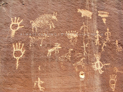
Both arrived on Friday night (the 16th), one by car and one by air. After a hearty breakfast of Swedish Pancakes (a family favorite), we hit the road on St. Paddy's Day morning. This time around, I wanted to see if I could find some petroglyphs near the trailhead. On my previous journey, I came across the well-known 'glyphs in the canyon, but another local adventurer (rock art fanatic) told me of another panel near the trailhead.
It was a warm day already and the wind was starting to pick up in advance of the next storm that would arrive on Sunday. A few high clouds, many terrain-induced were already setting up.
At the trailhead, I looked around for possible locations of the panel and discovered it without too much trouble. Again, with respect to cultural preservation, I won't divulge the exact location. But industrious folks who might decide to look for it should be able to find it without much trouble. Just a reminder, though... don't touch! Stand back, in awe and snap photos.
We explored the vicinity a bit and looked an old structure. I'm not sure if it was created by the picture-makers or someone else, but it was still cool to see.
As we were exploring around, I could swear that I smelled smoke. It turned out that someone had camped there the night before and did not fully extinguish their fire.
Pleased with the discovery of the "new to me" panel, I was eager to show my cousins the rest of the canyon, so we hit the trail. There were several other groups of people and a few cars at the trailhead, but it wasn't extremely busy.
Despite the wind blowing sand into our eyes occasionally, it was a beautiful day.
The Gunnison River and Sand Flat beyond.
Looking downstream on the Gunny from the pedestrian bridge to the old Bridgeport bridge.
I'll spare you the details of the entire hike and skip to the highlights. Last year, during the flooding in May and June, part of the trail had washed out. It was repaired to some extent and open to hikers but nothing else.
A dead Cottonwood at the canyon entrance.
Our first stop was the big waterfall. The water was a lot muddier than last year! We hiked around the waterfall and sat on an opposite ridge to eat some beef jerky, trail mix and Starburst jelly beans. Here are several photos of the falls. I couldn't decide which one I liked the best, so I've posted them all. I hung around on the ridge while Brad and Brian hiked back over to the top of the falls.
And now a couple with Brad and Brian for scale. The waterfall is rather impressive and surprisingly not listed on USGS maps. It does run year-round as I understand.
I joined them at the top of the falls and then took them a bit upstream to see the good petroglyph panels. We stopped at all the places that I visited last time, though avoided one panel since there was a group of people smoking pot there. I'm sure they had their MMJ cards.
Anyway, as we began to wander back, we noticed a couple of people at the top of the rubble at the base of the canyon wall. Sure enough, there was another panel; one that I had not seen on my previous visit. I was suddenly quite excited. As soon as they started to work their way down, we headed up.
I was pretty excited to have found two new panels on a hike I had already been on. Plus, it was great to be able to show the area to my cousins. On our way out of the canyon, their eyes were glued to the canyon walls looking for more. After being in the area for a while, I'm almost used to them... but it's awesome to see someone discovering them for the first time.
I was a little worried about Brian. He was in a pretty bad car accident a couple of months ago and ended up with fractures and a dislocated elbow. His arm is still healing and he had to wear a sling while hiking. Also, he was sick the night before. He was a trooper though and seemed fine on the hike.
When we got back to my place, I realized that though I had taken my sunscreen out, I neglected to put any on and was dealing with a wicked sunburn. I wasn't going to let that bother me, though. I invited a bunch of friends over and we grilled up some beer sausage made from elk and a ton of Hebrew National Hot Dogs. Then, it was a night of revelry downtown... it was Saint Patrick's Day after all.
The last thing I remember that night was the absolutely epic wind coming out of the south as we walked home. I soaked it up, to say the least.
Here's a useful map (click for larger):
Dann.
PS: We weren't done yet. Hanging Lake was next on our agenda.


4 comments:
i'm gonna make a petroglyph of you on a rock someday :) awesome photos, frick!
Thanks, man... just don't disturb the cultural heritage!
FYI the big waterfall doesn't run full year, though the water in Little Dominguez does (from what I've been told). I've been there several times in the summer, though, when the upper waterfall has run dry.
Ah, good to know. Thanks!
Post a Comment