Friday, August 29, 2008

Weather Spotting - August 29th

Lots and lots of subsidence today, but we also had a good convergence line. They fought a battle all day long, but the towers could never maintain strength. The typical form was the "Marge Simpson tower" (not pictured) ... and then they would mushroom and anvil right as the updraft lost strength. Made for some good pictures, though... and I have lots more which will be included in a full report eventually.


4:32PM


7:25PM


And finally, a beautiful sunset and convection deep into the mountains.


Dann.

Thursday, August 28, 2008

NWS Pueblo Releases Alta Vista Tornado Report

Go HERE and CLICK:


If the link is no longer available on the page, click HERE

Awesome! Note that they used my survey map. Also note that the preliminary rating was an EF1!

Dann.

Tuesday, August 26, 2008

2008 Storm Chase VIII Preview

Well, today was marginal at best. I had doubts this afternoon and was very close to not going before the Cheyenne Ridge lit up out ahead of tonight's cold front. That was enough to get me on the road. Michael wanted to go north to intercept the cells coming off the ridge, but I had a better feeling about heading northeast. We followed my gut and ended up in Brush, staring at a nice convergence line to our southeast.


The fact that one of the towers was flipping us off should have been enough to send us home, but we persisted. Eventually, the line died off and we decided to head back to the Cheyenne Ridge. ... but as we approached, those died as well.

The consolation prize? Pawnee Buttes ... I'd always wanted to visit and we weren't too far off. Michael humored me and we took a stop.


A few convective showers popped up out west, so we started to head back. Nothing spectacular to report ... saw a few lightning strikes that briefly caught our attention. We did make one stop to shoot but after two minutes out of the car, the mosquitoes had drained about two pints of blood from my legs.


We were almost tempted a couple of times on the way home as small showers popped up with a few strikes (it was a lightning mission at this point) but we just called it a night.

I think Tony's out shooting lightning as we speak ... we finally got some initiation along the cold front up north. I'm done for the night, though.

Full report eventually. ;)

Dann.

Monday, August 25, 2008

Tracking the Eastern Montana Heat

Wind shifts in northcentral Montana have limited heating, but every where south and east is still climbing.

Some obersvations:

Malta: 105º
Glasgow: 102º
Jordan: 102º
Laurel: 102º
Miles City: 101º
Winnet: 101º
Wolf Point: 101º
Columbus: 100º
Roundup: 100º
Billings: 99º
Glendive: 99º
Sydney: 99º
Bozeman: 98º
Livingston: 98º

Dann.

The Heat is on in Montana

Impressive ridge with southwesterlies cranking in central and eastern portions of Montana at the moment. Temps should cool from west to east as the day progresses, but not until some stations have topped out over the century mark.

Current Temperatures as of 1PM MDT

Bozeman: 98º
Jordan: 98º
Sheridan, WY: 98º
Livingston: 97º
Lewistown: 96º
Glasgow: 95º
Glendive: 95º
Miles City: 95º

Dann.

More Landspout Photos

These photos come from Big Sky Convection contributors, J & K Steinhilber of Castle Rock, CO.

The first two are of the Lemon Gulch landspout and the second two are of the one that touched down just after 6PM west of Castle Rock.


Sunday, August 24, 2008

Lemon Gulch Landspout (Castle Rock, CO area)

Images courtesy of Timothy Tonge (Skyview Weather)


DENVER LANDSPOUT(S)!


Velocity scans ... think this is the landspout right here.

LANDSPOUT!

... and I can't go out on the roof because of the DNC. Damn.

EDIT: The velocity couplet in the image is NOT from the landspout that was being tracked on Channel 7. This is a different one ... and possibly rain-shrouded.

Dann.

Mesoscale Discussion #2148

SPC has just issued Mesoscale Discussion #2148 concerning parts of Wyoming, Nebraska, and Colorado.

Dann.

Wx Discussion

I was looking forward to a nice trough digging through the country this coming week. The latest model runs, however, are keeping the energy to the north. I am now less enthusiastic about the prospects.

Meanwhile locally, we could have another good chance for thunderstorms today. The Democratic National Circus is in town, preventing me from gonig out on the observation deck to, well, observe. I don't want to appear to be a sniper or something and get swiss cheesed for looking at the clouds. So, I'll just sit inside in front of my screens and pretend I know what's going on outside. Storms have fired on the foothills again and we're very warm here at the surface in town. We are pretty much sitting at the convective temperature right now, so we'll see if things initiate. Plus, we have an outflow boundary moving in from the south and convergence setting up east of town. So, the ingredients are here and it's just a waiting game. If things do set off today, I don't expect anything much more than some small hail and wind. I don't see the storms getting too organized.

MONTANA

Eastern Montana could be seeing readings over 100ºF tomorrow as the southwesterlies kick up in full force out ahead of the incoming system. We'll see some decent downsloping (compression) off of the Beartooth and the Big Horns.

Dann.

August 23rd Recap

Wow, what a storm we had yesterday! When I got to work at the flood center at 1PM, I had a text awaiting me from Michael informing me of a wall cloud on a storm in the mountains, west of the city. I went out on the roof and saw it as well. I also took a bunch of pictures and video which I haven't had time to go through yet.

The storm persisted for almost three hours, slowly moving south and ever-so-easterly through Jefferson and Park Counties. All the while, rotation was evident and I could see the wall cloud from my roof top perch. To my surprise, there was no warning on the storm.

Eventually, the storm took on a more easterly component of movement and base reflectivity began to show a rather pronounced hook. The velocity scans were also spectacular. Finally, the storm was severe-warned and then tornado warned a few minutes later.

You can see a base reflectivity grab in my previous post here.

Though there were no tornado reports during the event, many trees were found "sheared" off and speculation is that it was a tornado. It wouldn't surprise me given the velocity couplet on the storm.


As for the Eleven-Mile Reservoir tornado/waterspout, this was a SEPARATE cell. In fact, I was watching it as the tornado report came across. There was no obvious rotation or supercellular structure to the storm. I'd wager that it was a landspout/waterspout. Here are a few links to photos and video:

KRDO Colorado Springs

KOAA Colorado Springs

FOX 31


Weather discussion for today and beyond coming soon.

Dann.

Saturday, August 23, 2008

Colorado Mountain Supercell


Oh man, a beautiful supercell has been rolling south on the foothills since 1PM. This image was from a half hour or so ago ... though the storm is weakining now. I observed a wall cloud with great rotation while it was up here. It has since moved south and east with rapid rotation ... was finally tornado warned. Now it's moving into more stable area off of the Palmer Divide and I expect it to weaken further.

Who says you can't get supercells in the mountains?

Dann.

Friday, August 22, 2008

Alta Vista Tornado Damage Survey

Michael and I conducted a "survey" of the Alta Vista Tornado today. It should be noted that since the tornado occurred, heavy rains had moved through the area and 9 days had passed since the touchdown.

When we arrived on the scene, we were hard-pressed to see any damage. Our first clue was twisted sheet metal along Alta Vista Road, northeast of where the barn reportedly had taken a hit. We did find the barn at the corner of Alta Vista Road and Berridge Road.

To the south of the barn, we saw a lot of debris (mostly sheet metal, plywood, and insulation) strewn about the field. In addition to that, we also found a fence that was knocked over. Upon further investigation, the fence looks to have gone down recently. The grass underneath the downed posts was very much alive and bent. Also, a large tire sat along the downed fence, the grass in similar condition underneath.

We cannot tell for certain that the tornado did this, but I speculate the tire was thrown from its original location and may have taken down the fence. (It was a heavy tire!) The fence is west of the tornado's starting point, so it would have had to "wind" westward in its track to interact with the fence. It should be noted that the fence on the other side of the road was not damaged.

I could see no evidence of shrapnel being driven into the ground or other objects; most of the debris appeared to have simply landed at the location.

We drove up to the house in front of the damaged barn to speak with the owner, but she was not home. We decided not to take any pictures while on her property, so all photos were taken while we were on the road.


The damaged fence.


Fence pole pulled from the ground.


The mystery tire.


The damaged barn (missing roof and front/back doors)


Final survey of the area.


Click on the below image for an expanded map of the area, including tornado track, various observation positions and debris fields.


Dann.

Thursday, August 21, 2008

Concerning Severe Weather Potential in Montana (August 21st)

SPC is considering putting out a severe thunderstorm watch in eastern Montana today per this Mesoscale Discussion

The heating is not that great today ... and thus instability is weak. What we do have is some good dynamic forcing, so the severe threat, while marginal, is possible. I agree that wind is definitely the main threat here.

Dann.

Back To Alta Vista

Michael and I will be traveling to Alta Vista, Colorado tomorrow to do an impromptu damage survey of the tornado we witnessed last week. Hopefully, with permission of the landowner, I'll be able to share some pictures and video.

It is a shame, but she had her barn destroyed by the tornado.

More to come.

Dann.

Tuesday, August 19, 2008

Severe Thunderstorm Watch #842 Issued for W. MT.


Storms should increase in coverage over the next few hours and organize into clusters. Expect damaging winds and hail up to 1.5".

Missoula County currently under severe warning ... expect that to extend into Lake County as well.

Dann.

Tropical Storm Fay Slams Kite Surfer Into Building

Yikes!

CLICK HERE

Dann.

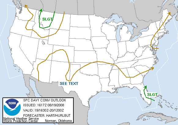
August 19 - Severe Weather Possibilities for Western Montana

The SPC has upgraded their convective outlook to "slight" for today.


I've taken a few minutes to look at the setup today.

On a large scale, a shortwave trough is currently moving through the area. This one has a little more punch to it than the "perturbation in the flow" type of systems we see in Colorado during the summer. The upper level low is located in Alberta and this shortwave exists as a "spoke on the wheel" so to speak. With the wave, there is a reasonable amount of mid level moisture and some decent lift as evidenced by the severe weather in Washington and Oregon yesterday.

At the surface in Western Montana, dewpoints are rather meager. The models (RUC 16Z and ETANAMWRF 12Z) seem to be overestimating the moisture at the surface. Dewpoints range from upper 40's in the northwest corner of the state to mid 30s in the higher terrain.

The cold pool associated with the shortwave should inspire some steep lapse rates, so terrain driven convection today is likely. In fact, some cu is beginning to form over the mountain ranges in Western Montana (not unusual for a summer day). However, with the lapse rates, and the propensity for lift from the upper level system, we could see some severe weather today. CAPE tops out at 1500J/kg and the wave will pretty much negate the cap, especially with the strong surface heating already evident.

Shear isn't exceptional, so I don't expect supercells. However, we could see some storm complexes form (possibly even linear mountain waves carrying the threat of high wind later in the day.) Earlier development should be more of single cell pulse storms capable of large hail. With tower height, updraft speed, and a lower 0ºC level the hail garden will be nice and fertile.

Tornado threat seems very minimal. Topography would have to be perfect to have a cell organize in that matter. ... while not impossible, the threat is very unlikely.

Heavy rain threat will exist with stronger storms or storms traveling over the same areas. However, most of them will be moving fairly quickly and preciptable water values are generally just over a half inch.


We will probably see a severe thunderstorm watch issued (that's my guess) at 2PM local time and also will probably see half a dozen hail and wind reports spread out across the western half of the state today.

Dann.

Record Heat In Western Montana

From the Missoula NWS:

PUBLIC INFORMATION STATEMENT...UPDATED
NATIONAL WEATHER SERVICE MISSOULA MT
830 AM MDT MON AUG 19 2008

A STRONG RIDGE OF HIGH PRESSURE BROUGHT HOT TEMPERATURES TO THE
NORTHERN ROCKIES OVER THE WEEKEND AND MONDAY. SEVERAL DAILY HIGH
TEMPERATURE RECORDS WERE BROKEN ON MONDAY AUGUST 18.

LISTED BELOW ARE PRELIMINARY METAR AND COOPERATIVE OBSERVER STATIONS
THAT BROKE OR TIED RECORDS FOR AUGUST 18.


.....METAR STATIONS - WESTERN MONTANA.....

NEW PREVIOUS
RECORD RECORD (YEAR SET)

MISSOULA 100 99 (1967)
KALISPELL 99 96 (1967)

.....COOPERATIVE OBSERVER STATIONS - WESTERN MONTANA.....

NEW PREVIOUS
RECORD RECORD (YEAR SET)

DRUMMOND 98 96 (1967)
LIBBY 32 SSE 93 90 (2001)
HAMILTON 99 96 (1934)
POLSON 98 96 (1919)
SULA 3 NE 93 (TIE) 93 (1999)
SUPERIOR 101 (TIE) 101 (2001)
THOMPSON FALLS 104 103 (1967)
WEST GLACIER 96 95 (1967)

.....COOPERATIVE OBSERVER STATIONS - NORTH CENTRAL IDAHO.....

ELK CITY 96 95 (2001)
PIERCE 100 98 (1940)

Dann.

Monday, August 18, 2008

August 16th Denver Flooding

The unseasonable weather left a lot of precipitation over the metro area, causing a gradual rise in streams. While it certainly wasn't flash flooding, both the South Platte River and Cherry Creek broke their banks.

Images courtesy of © 2008 Timothy Tonge/Skyview Weather


Sunday, August 17, 2008

Alta Vista Torando from Michael

Michael has posted his account of the Alta Vista tornado. He has some amazing photographs you should check out.

Click Here

Dann.

NWS Posts Recent Denver-Area Storm Recap

The Denver/Boulder NWS has added a write up about the unseasonable system which has been impacting the area for the last few days. Storm reports and rainfall totals can be found there.

Click Here

Dann.

Saturday, August 16, 2008

More Records (August 16th)

Denver sets a record low maximum temperature for two days straight, shattering a 118 year record! The high temperature at Denver International today was 58ºF, the previous being 63ºF.

There were also a few record highs in western Montana today (Polson and West Glacier included) ... and more expected tomorrow.

So, the northwest cooks, while Denver soaks in a cool, winter-like pattern.

Wild weather!

Dann.

Amazing Polish Tornado Video

Severe weather blasted through Poland yesterday including a couple of tornadoes.

Here, passengers watch in horror as a tornado bears down on them and topples their bus:

http://www.tvn24.pl/0,1561396,0,1,jezus--maria--idzie-na-nas,wiadomosc.html

BBC coverage:

http://news.bbc.co.uk/1/hi/world/europe/7565187.stm

EDIT
Here's a good collection of pictures. You can see the bus that toppled.

http://www.skywarn.de/forum/viewtopic.php?f=30&t=6009

And how about some hail?

http://forum.lowcyburz.pl/viewtopic.php?f=163&p=17209#p17209

http://de.youtube.com/watch?v=gLT43J4E96w

Dann.

Friday, August 15, 2008

Record Low High

Amazing weather here in Denver. A very unseasonable upper level low has been cut off from the flow and is just taking a siesta over the Rockies. We spent all day under thick cloudcover and persistent rain. It's hard to believe that two weeks ago, the temperature topped out at 104ºF. In fact, today's high of 59ºF (which was just after midnight) was a record low maximum temperature for the day, shattering the record by 9º!

Weather Service info:

000
SXUS75 KBOU 160100 RRB
RERBOU

RECORD EVENT REPORT
NATIONAL WEATHER SERVICE DENVER CO
700 PM MDT FRI AUG 15 2008

...RECORD LOW MAXIMUM TEMPERATURE SET IN DENVER FOR AUGUST 15TH...

THE HIGH TEMPERATURE AT DENVER INTERNATIONAL AIRPORT TODAY WAS 59
DEGREES.

THIS WILL REPLACE THE OLD LOW MAXIMUM TEMPERATURE RECORD FOR AUGUST
15TH WHICH WAS 68 DEGREES SET 128 YEARS AGO 1880.

KTF


We are also under a flood watch as moisture will continue to stream into the area. It's not raining right now, but I suspect with any heating tomorrow, showers and thunderstorms will redevelop. The models are keeping the low around for a while, so the rain could continue into Sunday.

... I'm loving the cool weather. It's very refreshing!

Dann.

Thursday, August 14, 2008

FINALLY!!!


Meso/Wall


Funnel


Touchdown.


More to follow. Encoding video (which shows funnel to surface circulation) right now ... full report eventually.

EDIT:


Wow, what a day.


Dann.
PS: Be sure to watch Good Morning America in ... well, I guess like five and a half hours. ;)

Tuesday, August 12, 2008

20080812 Wx Chase

Ran out for a quick little storm pursuit tonight.

I learned a few things:
1) I don't know the road network near my new apartment very well.
2) Sometimes you should just stop, even if you have a marginally-good vantage point.
3) Those first two are pretty important.

I did see a broad circulation, though ...

Not much lightning. Maybe two or three flashes in the 45 minutes I was out.


More pictures of the event on Tony's Blog

Dann.

Monday, August 11, 2008

Video from August 10th

The storm rolling down the foothills exhibited supercellular characteristics at tiems. There was what appeared to be a wall cloud, but I didn't observe any rotation.

See for yourself:


Dann.

Is That A Python In Your Pants?

This KCCI broadcast met has quite the experience ...


Depress Left Mouse Button Here


Dann.

20080810 Wx Report

Another day at the flood center for me. The shortwave pushed some showers off of the mountains, but they never really developed. Outflow from storms on the Palmer Divide did set off a few storms east of town, but nothing exciting.

In the early evening, an outflow boundary pushed up against the foothills, sparking a storm which rode the foothills southward. It was very photogenic:


Nearing sunset, it had reached the south end of town.


Later on in the evening, Jon Van de Grift activated the lightning net, so on my way home from my aunt & uncle's house, I set up on the far north end of town. I sat there for probably a half hour with a pounding headache, taking shots. It was pretty frustrating too as I didn't have my tripod, so I was using the windowsill of my car to take shots. Without any obvious motion, I was still getting really blurry, light-streaked photos. Especially the few with lightning! I have a few, perfectly crisp photos of just landscape. Grr.

I finally gave up and headed back into Denver. Lightning to the south of town, however, caused me to stop one last time and set up again. So, I pulled into the parking lot of the flood center (I knew it had a good view) and shot again. Again, I got blurry photos! I was pretty frustrated again ... got a few really crisp shots, but my only CG is really blurry. Just be glad it's a small version ... I wouldn't click on the full-size. ;)


Dann.

Sunday, August 10, 2008

20080810 Wx Discussion I (2043Z)

COLORADO WEATHER

The Weather Service has the Denver area under a Flash Flood Watch again today, which I believe is warranted. The models are having a tough time resolving everything today, with some disagreement pertaining to storm coverage and intensity. One thing I did notice that was different than yesterday though was that we have a good deal more instability to work with. The RUC (which has been overestimating CAPE lately) is showing upwards of 2,000 J/kg. While it's probably not that high (especially due to lack of heating in the metro area due to the alto cumulus layer), we still are dealing with a less-stable atmosphere than yesterday. Couple that with the abundant moisture and the approaching short wave, it should be enough to set off some good rainers today.

In fact, storms have already developed over the higher terrain and Palmer Divide areas today. Even to the east of the city, we have some storms building on convergence zones.

Right now, storms are beginning to eject off of the foothills. While storms usually weaken off of the mountains, we also have a strong outflow boundary moving in from the southeast. This could be enough to really set some storms off, especially if we end up with some good convergence over the metro area. I will be monitoring this situation closely.


MONTANA WEATHER

The possibility for severe weather exists again today, but mostly in the eastern portion of the state. A storm already put down a tornado in the far southeastern corner of the state (Alzada).

1839 9 NW ALZADA CARTER MT 4511 10455 TWO FUNNELS ENTWINED INTO ONE TOUCHING GROUND (BYZ)

Got to love that description ... hope someone got a photo of that!

Anyway, the same shortwave that is stirring up trouble in Colorado today is a little bit stronger in Montana. There is much more wind shear to work with lending to the probability of organized severe storms. We will probably see a few more supercells today but most storms will be organized in clusters.


Dann.

Saturday, August 09, 2008

20080808 Wx Recap

So I ask for one day off this week, one day! And sure, it was nice to go out to dinner with my old landlords and roomies, but what a party I missed!

Okay, so when I say I asked for the day off, I meant from the flood center. I worked my other job all day yesterday (8AM to 6PM). As I was leaving the office down at Inverness, I noticed that the cap had broken. It had been hot and muggy all day and the 750-500mb temps were just a little too warm to get things lifting. There had been storms over the mountains all day, but one was now sitting over the foothills and looking rather tenacious.

I proceeded to my old house to meet my old roomie and carpool up to the north side of town for dinner. I did a quick check of the radar and saw a nice outflow boundary coming from convection to the north, stretching from the foothills past Greeley. It was headed in a general southward direction and I had a feeling it might interact with the storm just exiting the foothills.

While waiting to be seated at dinner in Westminster (104th/US 36), the outflow came through, blowing leaves into people's margaritas.

While I was enjoying dinner, apparently, all hell broke loose. The storm came off the foothills right into Denver, followed by the outflow boundary which set it off like TNT. The big problem was that the storm didn't really move. It just fed off of the available moisture and sat over Denver county, prompting flash flood warnings.

I didn't know this until checking the radar after leaving dinner. It would have been a fun night to be at the flood center. I called the new guy, Nick, anyway, to see how his first day (alone) went. Talk about being thrown into the fire. He told me some places in Aurora had already reported 2.5"+. I was shocked!

Heading back down into Denver, highway marquis warned of standing water on the freeway near Alameda, so we opted to take Spear through town. Cherry Creek was over its banks and had risen up the concrete walls abutting Spear. I couldn't believe how much water was flowing through it!

Aside from a bit of lightning, the storms had moved off to the east by this point and it was no longer raining.

Here is a time sensitive radar loop. (Should be valid through 8/12)

KFTG BREF

NWS Rainfall totals.

Dann.

20080809 Wx Discussion I (1458Z)

Hi, just a quick post as I'm on my way to help one of my old roomies move into her new place ...


COLORADO WEATHER

There is a lot of moisture still hanging around in the area. The west slope should see some good terrain forcing with another weak disturbance rolling through the area today. Flash Flood Watches are up all over the west half of the state.

In the Denver area, the possibility of heavy thunderstorms exists again today. We could be in big trouble if they form in the same areas as yesterday (3" of rain in Aurora!).


MONTANA WEATHER

The west half of the state is ripe for some severe weather today. Moisture isn't great, but with a wave moving through, we'll have enough shear to get some strong storms rotating a bit. Large hail is possible, but it looks like wind will be the main threat.


More later (hopefully).

Dann.

Friday, August 08, 2008

20080807 Wx Recap

COLORADO

So, we didn't have any outflow boundaries and didn't have significant heating yesterday. Thus, nothing was even close to breaking the cap. It was pretty interesting too, because the soundings coming from planes at DIA were showing a really deep warm layer in the mid-levels. Nothing could break through.

Dann.

June 27th, 2007 Elie, Manitoba "F5"

This is not my video but one that I saw last year. I wasn't able to find it again until today, so I figured I would post it. It's incredible footage.


"It's not the mill, it's the town."

That part really gets me.

Dann.

Canadian Tornado Frequency


Click image for larger view.

Dann.

Thursday, August 07, 2008

20080807 Wx Discussion I (1703Z)

COLORADO WEATHER

Flash Flood Watch again today. Most of the moisture is still hanging around. I think we'll need less of a triggering mechanism today as we did need one tomorrow. Any significant heating at all should send up some cumulus. Moisture is abundant and heavy rain with occasional downburst winds should be the name of the game. When the heating goes away tonight, everything SHOULD dissipate.


MONTANA WEATHER

RED FLAG WARNING
NATIONAL WEATHER SERVICE MISSOULA MT
757 AM MDT THU AUG 7 2008

...RED FLAG WARNING REMAINS IN EFFECT FROM NOON TODAY TO MIDNIGHT
MDT TONIGHT FOR SCATTERED THUNDERSTORMS ACROSS THE EAST LOLO...BITTERROOT..
DEERLODGE/WEST BEAVERHEAD...EAST BEAVERHEAD..

A RED FLAG WARNING REMAINS IN EFFECT FROM NOON TODAY TO MIDNIGHT
MDT TONIGHT.

INCREASING INSTABILITY AND MID LEVEL MOISTURE OVER SOUTHWEST
MONTANA WILL LEAD TO THE FORMATION OF SCATTERED THUNDERSTORMS
TODAY. THE LOWER ATMOSPHERE REMAINS VERY DRY. THUS THUNDERSTORMS
WHICH FORM TODAY WILL PRODUCE LITTLE PRECIPITATION. GUSTY...ERRATIC
WINDS AND FREQUENT LIGHTNING CAN ALSO BE EXPECTED NEAR THESE
STORMS.

A RED FLAG WARNING MEANS THAT CRITICAL FIRE WEATHER CONDITIONS
ARE EITHER OCCURRING NOW...OR WILL SHORTLY. A COMBINATION OF
STRONG WINDS...LOW RELATIVE HUMIDITY...AND WARM TEMPERATURES WILL
CREATE EXPLOSIVE FIRE GROWTH POTENTIAL.


Dann.

20080806 Wx Recap

Being a budding meteorologist with limited forecast experience, I think it's important to be aware of my mistakes.

Yesterday, I relied way too much on having a persistent pattern in place, basically allowing for a repeat of Tuesday's setup. This wasn't the case as even while forecasting yesterday, I missed a surge of air that moved in from the north and changed a lot of the mesoscale dynamics. I've tracked the "surge" to an outflow boundary that traveled south overnight from severe storms that formed in northeast Wyoming. This northerly flow temporarily trumped the easterly upslope that I had expected. Eventually, however, the easterly winds began to overpower the northerlies, which led to a convergence zone (northwest vs. northeast winds) along a line from Thornton to Lakewood. The air from the north was just as moist as our easterly upslope, but it was a little cooler. As a result, the air over the metro area stayed a little more stable, a little longer. If it weren't for this push, I'm sure that the airport would have seen 90ºF once again. Unfortunately (fortunately), the streak will now stay at 24 days.

As expected, the mid-level moisture from the west continued to advect into the area throughout the day. Even though the surface got out to a slow start in the heating aspect, it soon began to cook nicely. By mid afternoon, cumulus began to form but was capped by a stable layer (which could be seen by a field of altocumulus). As the day wore on, the cumulus became more intense, and though not extremely strong, began to push through the stable layer. As the convergence zone strengthened over the urban corridor, the propensity for lift was very evident.

All eyes, however, were on an outflow boundary moving due-west from convection in eastern Colorado. On RADAR, it appeared as a flying-V formation (think migrating geese) and was pointing directly at Denver. Meanwhile, the cap over the city broke in spectacular fashion and stationary moisture-laden storms blew up. These storms were putting down 0.50" of rain in a half hour, right during evening rush hour.

The storms didn't really move, maybe drifting (or building) slowly to the west. At this time, however, the outflow boundary from the east was now in the metro area. In its wake, stationary storms were blowing up and dumping rain over Adams and Arapahoe Counties. When the outflow boundary finally met the convergence zone, they interacted in spectacular fashion. It was like watching a game of "red rover". Outflow from the original convergence line was now pushing east in opposition of the incoming boundary. Each boundary exploited the weaknesses in the other, causing an amazing scene.


As you can see in the radar capture, some areas of the line pushed through the other. On the edges of these opposing charges, rotation became evident. Soon, tornado warnings were issued as people began to see funnel clouds and even weak tornadoes. Again, the NWS has not yet issued any sort of statement or report after the fact and the SPC has no record of a tornado. The spin-ups were likely brief and weak and may have been gustnadoes or landspouts. It was very interesting to go out on the observation deck and hear the tornado sirens ringing in downtown Denver. That's only the second time in my life I've heard tornado sirens (the first being in Fort Lupton last year).

The convergence of the boundaries led to heavy, heavy rains in many areas. Storms continued to fire and remain stationary for the next few hours before lack of heating sounded the death knell. Another interesting sight was the broad circulation that seemed to hover about the area in the late hours. Moderate rain continued to fall in the metro area after dark while the plains saw heavier precip.

Here are some rainfall totals from yesterday:
Brighton (North): 2.48"
Brighton: 2.44"
Aurora (Havana Park): 1.38"
Denver International Airport: 1.31"
Henderson: 1.26"
Aurora (Toll Gate Creek at 6th): 1.18"
Aurora (Aurora Regional Pond): 1.14"
Denver (Diamond Hill): 1.10" (My location)
Arvada (West Woods): 1.06"
Thornton (Niver Detention): 1.02"
Denver International Airport (Third Creek): 0.98"

All in all, it was a fun day. I learned a lot and had a great time at the flood center, even though I was there until 10PM!

Dann.

Wednesday, August 06, 2008

High Speed Lightning!


Found by Dan Robinson and forwarded to the Storm Track bulletin board tonight.

20080806 Wx Update

Wow, what a day it has been! Flooding, hail, tornadoes, oh my! I'm still at the flood center and should remain here for the next couple of hours. It's going to be a late night. The amount of moisture being advected into the area is phenomenal. I'll try and do a full recap of the day's events tonight when I get home or possibly tomorrow morning.

Dann.

20080806 Wx Discussion I (1556Z)

COLORADO WEATHER

Today's forecast is very similar to yesterday's. We can add a little bit more moisture into the mix today. Take a look at Grand Junction's 12Z sounding from this morning as it is a taste of things to come here in Denver:


Denver's sounding was a drier between 450 and 800mb. Surface winds are kicking up out of the southeast and should switch to the east again this afternoon. Dewpoints are already in the 50's over much of the area. As the moisture moves in in the mid-levels from the west this afternoon (helped out by a tiny shortwave moving through the flow), we will be deep in moisture.

Again, like yesterday, convergence will be key outside of terrain-based lifting. I would almost expect to see a similar area of convergence on the east side of the metro today with light westerlies off of the foothills and the south-easterly flow on the plains. The foothills and Palmer will fire early, probably before noon again. Outflow boundaries could play a rather chaotic role in storm development again today, so they will have to be watched.

Taking a look at Denver's sounding:


... we can see that there are no reasonable steering winds today until you get above 450mb. With the increase in moisture and lack of storm movement, today could be another flood day. Looks like it will be a long day of metwatch. :)

Dann.

Tuesday, August 05, 2008

Chicagoland Tornado Confirmed ... Too Close

Wow, a tornado touched down as part of the derecho yesterday very, very close to someone that I know. The path begins only one mile from their house. Scary.


Click image for larger view.

Further details can be found here.

Dann.

20080805 Wx Recap

So, remember how I said it would be tough to reach that 90ºF convective temperature ... well, we did. In doing so, Denver reset the record at 24 days!

Massive convergence occurred on the east side of town today. More than an inch of rain was recorded at a few stations in or near Aurora. There was even an unconfirmed report of a tornado. Aurora dispatch called me at work to confirm and while I did see a brief signature on RADAR (looked to be a landspout), I referred them to the National Weather Service. As awesome as it would have been to comment officially on it, it's not my job. We're concerned with flooding.

An outflow boundary blew into the foothills later in the day and caused a stationary storm to form between Golden and Boulder. Some gauges picked up 1.5" of rain!

It was a fun day to be in the metwatch seat. I got to issue four separate storm tracks and spent a lot of the day on the phone with various agencies in the metro area.

It's nice to have a little rain around.

Dann.

French Tornado Damage Video

French Tornado Damage Video

Dann.

20080805 Wx Discussion I (1818Z)

COLORADO WEATHER

Today should prove very, very interesting. We have some moisture and we have some lingering boundaries from yesterday's convection. We also have mid-level moisture ... lots of mid-level moisture ... ready to be tapped and exploited. What we don't have is instability today. The surface temperature would have to approach 90ºF to lift us today and with noon-time temperatures in the upper 70's (thank you cold front!), 90ºF is a stretch. Also working against us is a lack of reasonable shear. Head north and you'll find it, but the metro area is lacking, not to mention warm temperatures at 700mb, effectively capping the atmosphere. Winds are erratic and weak until you reach 500mb where they blow out of the west

So, what does this all mean?

Well, we'll have to look to the mountains and foothills to see decent lapse rates capable of driving convection. With the moisture in place, this shouldn't be a problem at all. Mid-level outflow could inject more moisture and cool the mid-level temps, weakening the cap over the plains, while at the surface, outflow boundaries pushing from mountain convection will collide with existing boundaries from yesterday giving just enough lift to break the cap.

Storms that do form will be able to take advantage of close to 3cm of precipitable water and lack of steering winds could hold them in place. Storms could also ride the boundaries, leaving pure chaos on the plains. Some pulse storms that reach decent height could also produce some hail today, though wind and minor flooding appear to be the main threats.

I'll be working at the flood center today, so call if you need a nowcast.

Dann.

Midwest Derecho

Wow, what a perfect example of the derecho last night in the midwest. I was trying to figure out why the Cubs game was rained out when I looked up SPC and saw that they had just upgraded to Moderate severe risk and that the derecho was bearing down upon Chicagoland. (see radar image below). Plenty of high wind reports including a tornado report in Elmhurst resulted from this storm.


This video, I believe, was from the first rain delay at Wrigley.


... and just when the Cubs game got going again, lightning struck very close by. There was great footage of it during the game, but I can't seem to find it online yet.


Oh, and they ended up calling the game at that point and the poor Cubbies lost. :(

Dann.