Saturday, March 27, 2010

2010 Storm Chase 2 Report - March 26th

Forgive me Father... It had been sixty four days since I had chased...

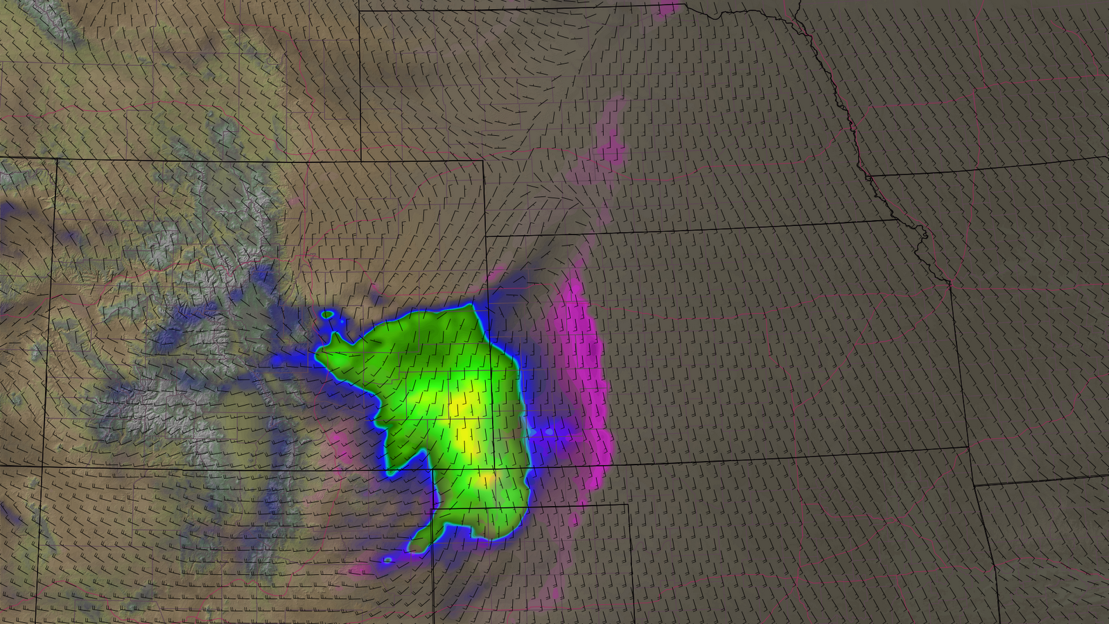
Over the past couple of weeks, I have been half-fascinated by the way the NAM has, on occasion, displayed large amounts of CAPE due to enhanced surface moisture from snowmelt/evapotranspiration. By on occasion, I can refer to two. The first was a relatively calm day in zonal flow and of course, none of this potential was realized. On this occasion, however, a system was coming through. The NAM was obviously very high with surface moisture due to snow from earlier in the week, but with upper level support, my fascination lead me to go experience this in person. Though I knew it was overdone, I guess I really just wanted to see the situation in the field.

At the very least, I knew there was going to be some convection and having not been out in over two months, I just wanted to go out and hear some thunder and maybe see some hail. And who knows, nature's full of surprises. I enlisted The Great Larouche to join me and was misleading at all in my convincing of him to go. "Chase" was an awful strong word for this endeavor... but we decided to deem it "convective investigation".

We set out of the Denver area by 1:45PM and made our way south and east toward my initial target of Lamar, Colorado. The NAM actually had 50ºF dewpoints there! In reality, the dewpoints struggled to get out of the low 30's. I was obviously hoping for something more than that. Winds were out of the north to northeast throughout the trip down to Eads, Colorado, where we briefly stopped to get our pictures taken with the town's amazingly large sign which proclaims them, "home of the eagles". (See my recent Facebook postings for details)

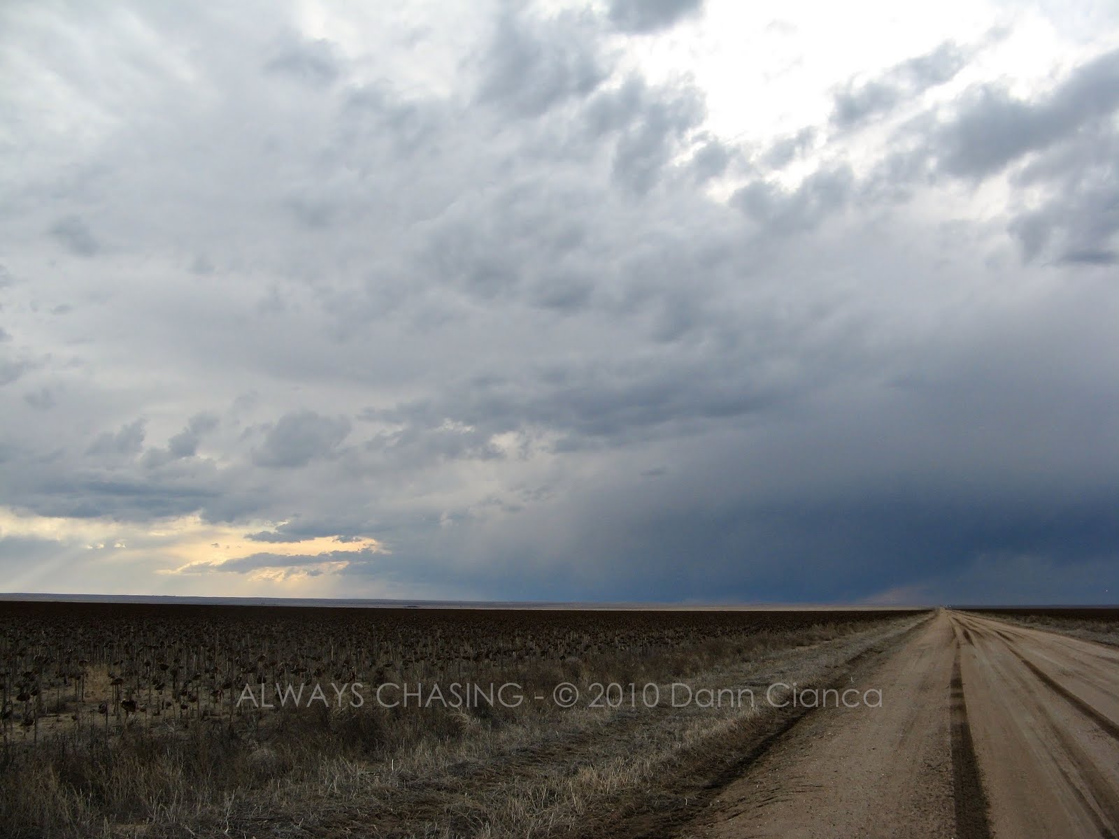
There was convection on the south side of the Palmer Divide, as I had forecast based on the different models' output. Most of it was distant to our west however and I was a little hesitant to leave my Lamar target. We stopped as a high-based virga shower moved through.


However, a bit south of Eads, I realized that a "ten" wasn't necessarily going to walk through the door, so I had a drink and decided to browse the field. Pickings were scant, but we decided to head west on dirt, a few miles south of Eads. We passed through the "shower" with barely a sprinkle and found some sunshine. Most of the convection was still a way to our south and west, so we stopped and kind of goofed around for a bit.

I left the water spot on the lens because I liked it. Don't hate.


I made the mistake of laying down on the ground to get an interesting perspective and thought nothing of it as it was a field of dead sunflowers, but when I got up, I discovered about forty marble-sized burrs stuck to my arm and leg. I tried to pull them out and ended up with bloody fingertips.

Dear Grandma,
Thank you for giving me the pair of deer skin gloves for Christmas a couple years ago. While they have remained in my car and are usually used during ice scraping operations, I found them very useful this Friday as a means to successfully remove hellish spikeballs that were stuck to my clothing and attempting to drain my body of its red, iron-rich fuel.

Sincerely,
Dann


We soon realized that the storm(s) to our southwest was looking a bit better on radar, so we decided to continue on and come up with an intercept strategy. A few miles south of Galatea, we stopped again to assess the situation and noted that the storm was looking more organized. Due to the surface wind field, I wasn't paying a lot of respect to the storm, but again, it started looking better.


The surface winds were strong, cool and out of the northeast and while this storm may or may not have been elevated, I realized that technically, the vertical profile was conducive for rotating storms. We were also starting to see distant cloud-to-ground lightning strikes which was good. We got back on a state highway at Haswell and decided to head southwest to get underneath it. The base was intact and was crescent-shaped, which can be more easily see on some of the images above.


We passed in, closer to the updraft along the highway and while I was trying to make haste to catch an east-running dirt road out of Arlington, I neglected to do much in the way of photography/videography. I wish I had been more on top of things (and hopefully Kendell was) as for a period of time, the base lowered and was barrel shaped. Due to our motion, I was unable to ascertain any realistic rotation, but I would not be surprised if there was at least a weak spin. At this time, we were passing through light rain and occasional melted hail (in the form of slushballs). The lightning became more frequent as we passed close to the updraft.


At this time, I'd like to share with you one of my favorite moments of the day.

Me: "Kendell, how far are we away from Arlington?"
K: "Just a couple miles. We have to pass through a place called 'Windmill' first."
Me: That may actually BE a windmill.

Okay, well I thought it was funny.

We headed east out of Arlington on dirt/mud and continued to get pelted with slushballs. The cloud-to-ground strikes were close and all around us, which was awesome, but we kept our eyes on the updraft immediately to our south. It didn't really do much except lower down a couple of times.

We continued east to a paved road which ran north-south between Haswell and US50. It was starting to get dark, so I wanted to get us in a good position for lightning, so we went south after taking one last look at the updraft.


Once on US50, we continued east until we were dry (though we got into some brief pea-sized (non-slush) hail, which was nice. Once dry, we got out and tried to shoot some lightning.

I struggled to have an oppen shutter during the strikes and as a result only captured one bolt in frame (but it was tiny and behind a tree, so I'm not even going to share that image). Instead, I'll share a couple of low-light scenes of the storm as night fell.


We got into the car to reposition as it had started to rain, but soon noticed that there was no more lightning... at all. So, we continued to Lamar to grab a bite to eat and get gas. I was expecting some more convection in the area after dark as the support moved through, but nothing really happened in southeast Colroado. There was a bit in Kansas, but it wasn't anything worth looking at. Aside from some last gasps of outflow from our dying storm kicking up dust in Lamar, we didn't witness anything else of a convective nature.

In fact, the expected journey home through the snow was disappointing, if you could call it that. Basically, there was no falling snow at all! In fact, only a light dusting coated the sides of I-70 between Cedar Point and Deer Trail (accompanied by a bit of fog), but the road (at least the right lane) was completely dry.

Upon arriving home and having some time to look at data, I'm pretty sure we were on the best storm of the day. I also believe that it attained brief mini-supercellular structure. That would explain what we were observing, though I would like to have a profile of the surface-to-cloudbase winds.

The radar images below are base reflectivity (0.5ºtilt) and storm relative velocity. The storm we were on is the small 35-40dBz flying-eagle shaped cell north of La Junta (57/40ob) and southeast of the large, higher-reflectivity mass near Pueblo. Click on the radars for much larger images.


Honestly, I had a lot of fun. I really just wanted to get out under a storm and be out on the open road.

Total mileage: 522
Copilot: Kendell LaRoche (The Great Larouche or Nasty K)
Nowcast support: Michael Carlson, Johnathan Skinner

I usually post a map of my route on each individual chase. However, Google Maps will not allow me to use dirt roads in the process, which is strange because it worked fine up until this point.

Also, my new camera has decided to be incompatible with Adobe Premiere which I find of great annoyance, so no video from this chase, at least in the short term.

Dann.

Friday, March 26, 2010

Convective Daytrip

I am free from work in a few minutes and plan to head out to the plains today to experience some convection. Moisture is lower than the NAM was predicting (as was expected), but is slowly rising. Lamar's Td is up to 37ºF and this is the area I am targeting. I believe with a little more time (heating and evapotranspiration of snowmelt/runoff) and moisture convergence as the surface features move in, we'll see low 40's in the Arkansas River valley near the Kansas border. Lapse rates are great, so we should at least see some convection on the south side of the Palmer Divide this afternoon. Severe weather is unlikely, but I want to be out there to make sure!

Later tonight as the upper level support really moves in, lift will increase, especially into SW KS. Unfortunately the surface will be inverted by then, but elevated storms work just fine for lightning.


I will post occasional updates on Facebook and will be on Spotter Network.

Also looking forward to the drive home tonight... in the snow.

Dann.

Thursday, March 25, 2010

Call It An Adventure, Call It An Investigation

So, tomorrow... heh...

If you'll recall, in a recent entry, I talked about the NAM overdoing CAPE values due to evapotranspiration/snowmelt. This appears to be the case again tomorrow. However, with a bit of upper level support and some surface convergence... anyway, I'm curious. The NAM is resolving close to 2,000J/kg of CAPE over SE Colorado tomorrow and while I believe that is really overdoing it, I do believe there will be some convection tomorrow. So, I'm going to go out and document what I see.


Today's 18Z run with a valid time of 0Z Saturday CAPE, CINH, 10m agl winds


Oh... and snow on the way home.

Dann.

Wednesday, March 24, 2010

Adding Winds


(click for a much larger image)

Playing around with the CAPE/CINH product and adding a plot of gridded wind data (a composite of the U/V vectors.

What do you think? Too busy?

This product was created using LEADS software. (IPS Meteostar)


Additionally, I did take a lot of video of the windy winter storm yesterday, but I have yet to master an efficient way of retrieving video from my camera and being able to work with it. Maybe I'll get something going tomorrow night.

Saturday, March 20, 2010

A CAPE Can't Make Ya' Fly, Kid

While I was at work on Friday, I recall looking at the NAM and seeing a ton of CAPE over Colorado at 0Z on Tuesday (Monday night). Up top, nothing special was going on, so I was a bit confused... until I realized what it was doing. In fact, I made a nice image that I was going to use to explain it... but then forgot to send it to myself. The NAM backed off on things with later runs, so I forgot about it, until tonight. Now I'm seeing the same thing on the NAM for 0Z Wednesday (Tuesday night)


Same forecast time, different run (being today's 0Z). Impressive CAPE, no?

Unfortunately, it's ghost CAPE. The NAM, apparently, is completely high on evapotranspiration. The CAPE? Blame it on the snow! Take a look at the model vertical profile below (Denver at 0Z). Where's the moisture at?


... the surface. RIGHT at the surface and then it's high and dry! Why is there so much moisture at the surface? The answer is melting snow (which I believe the NAM is seriously overestimating.) Don't get fooled by the weak southeasterly winds a the surface, either. It's not moisture transport at work! It's a natural tendency here along the Front Range when we're in zonal flow like that. (thus the DCVZ and Denver Cyclone)

If you mix out any of that moisture at the surface... you end up with no CAPE! While the lapse rates are great, the high CAPE is calculated with high surface moisture. Notice also, that the model composite reflectivity leaves eastern Colorado rather empty. Anyway, just wanted to save someone a trip. I'm surprised no one has started freaking out on Facebook about it yet.

I guess everyone is too busy looking deep into the recesses of the 300 hour region on the GFS. :)

Dann.

Thursday, March 18, 2010

March 19th Final Update

Over 24 hours ago, I decided to forgo this trip to Texas. While I think there will be some severe to be had, it's just a little too marginal and a little too out of range for me, especially given the snow I would likely encounter on the way home. So, I'll save my money and my paid-time-off for the future and will watch this one from the sidelines.

Tuesday, March 16, 2010

Severe Weather/Chase Forecast: March 19th - Tuesday Update

Ick! I'm having a little déjà vu here...

The models are doing a pretty good job at killing off the opportunity of severe weather on Friday. The NAM and GooF are in general agreement as to the placement of the upper level features, though the NAM is a tad behind with the upper level trough. Interestingly, because the upper level features are a bit behind, the surface features from the previous, northern system are ahead. So, with the NAM, we have the polar air mass based cold front 100-200 miles further south than the GFS. The GFS, which is slightly more progressive up top is initiating lee features of its own which are holding the northern cold at bay to a larger extent. The cold front will eventually sweep through the panhandles in both cases, but the timing is just a bit different.

I was hoping for a little dryline play before the cold front gets there but the models are both showing decent capping down south. In fact, almost all of the instability depicted on the NAM is significantly capped. On the GFS, a little bit of instability remains uninhibited or only slightly inhibited in NW OK, but the instability is weak there. On top of everything else, I was hoping to see the winds take on a more backing look out ahead of the cold front, which the models have also backed off on.

So, that's a downer... and not to mention the snow behind the system, in both cases, looks to be troublesome.

Though it's obsolete now, I made an image of CAPE and CINH today at work based off of the 18Z 12.19KM NAM (The CINH is in pink-purple and the CAPE in Dark blue 0-500J/kg, Green 500-1000J/kg Yellow 1000+).


Image created using LEADS software. www.meteostar.com

Who knows what the models will do... I've asked for the day off and know a few others might be willing to make the journey, so we'll see, but I've lost a lot of optimism tonight.

Dann.

Severe Weather/Chase Forecast: March 19th

Well, the next one is on its way down the pipe, so it's time to get the discussion rolling.


Synoptics:

Both the GFS and ECMWF are in agreement as to the orientation of the system, showing a positive to neutrally tilted trough digging in through the West late on Thursday. Now currently, a nice negatively-tilted trough is working its way into the Northwest and it will eventually break down the ridge that has its grip over most of the west. The interesting thing here is that before the ridge breaks down and the trough digs across the west, some of the energy will be directed through the Canadian Praries, which will cause a surface feature that will tap the cold polar airmass... but I'll get to that in a moment.


The Surface:
A surface cyclone will slide from Alberta across the US/Canadian border on Thursday, in its wake, a deep cold pool pour down the lee of the Rockies. By the time Friday morning rolls around, the edge of the cold air will already be into Colorado (the NAM being more progressive than the GFS) Meanwhile, in Texas, surface troughing ahead of the digging upper level trough will begin to take shape. Moisture advection will be in full swing ahead of the system, though not for a long amount of time.

By 0Z Saturday (Friday night), the GFS has a strong airmass boundary from Amarillo to Chicago with cold air to the north (20's on the Colorado plains!) and warm, moist air to the south. (60's into KS, 70's in the TexPan with 50Td's into KS) Shear is great in Western Oklahoma, especially near the surface though winds aloft leave something to be desired. The 0Z run tonight backed off a bit on the instability, but still has 750J/kg near Woodward and though one shouldn't "bullseye" chase, Woodward or points a bit southward seems like a reasonable target, especially since I have a feeling that the 12Z NAM run is not going to make anyone happy about this situation, including myself, given its progress of the polar airmass.

The GFS isn't closing off a surface cyclone until 06Z on Saturday, south of I-40 along the Texas/Oklahoma border.

Given the dynamics, vertical profiles, and surface features, I don't see any reason why we shouldn't have a few supercells in W to NW Oklahoma on Friday afternoon/early evening.

I asked for the day off of work so I plan on going if the setup is the same or better. So, some of you may expect a text message tomorrow for carpooling options.

... another important thing to mention here is that the GFS is indicating there will be a LOT of snow behind the cold front. Palmer Divide amounts look to be 6+" (with strong northerly winds) and even more than a foot in the Salina, Kansas area by Saturday evening! This could be a very interesting system, so I'll be watching it very closely.


Your thoughts are welcome.

Dann.

Monday, March 08, 2010

The One That Got Away

From my post last night:

The models just haven't resolved anything worth chasing. The distance involved trumps any desire to see what develops. If it was local (meaning the EaTexPan or WeOk), yeah, I'd probably head out and have fun, but a 500 mile drive... no way José! Even the cold core in Kansas just isn't enough to bite on.

Ouch. This one hurts. In all fairness, though, the models just didn't show me what I wanted to see to make the drive all the way down. It was inconsistency... it was not the shear profile I was looking for.

You'd be hard pressed to find anyone who was forecasting anything more than a brief spin-up today, so I don't feel too bad I guess. Congratulations to Johnathan Skinner who just so happened to be staying with friends in Elk City last night! He told me that it just so happened to be right where he was targeting, so that worked out VERY well for him. Undoubtedly, we would have met up with him at some point and time today, but there is a long list of "if's" that I could get into tonight.

Anyway, we'll leave it at that for now.

So, two other things.

Today at work, I spent a good deal of time on new product creation. I wanted to make a CAPE product that had CIN overlaid on it, basically blocking out the CAPE when the CIN is strong enough. In the example below, the CIN (pink-purple) is opaque at -100J/kg. At values between 0 to -100, it is translucent, thus allowing you to see the CAPE(blue-green-yellow) below it.

The CAPE is translucent below 200J/kg or so and the blue colors stop at about 500J/kg where they switch to green. Yellow is 1500-2500J/kg and above that (but not shown) it goes to orange and red and finally a light (not bright) pink at about 5000J/kg.

I put the parameters (in this case the 21Z valid time from today's NAM 18Z run) with IR and VIS sat images.

CLICK ON IMAGES FOR A MUCH LARGER VIEW!!!!


Note: These images were created using IPS Meteostar's LEADS software. Interested parties in the software may refer here: http://www.meteostar.com/company/contact.html

Though I work there, I'm not here to sell per se. I just wanted to show you how awesome we can do stuff! Anyway, interested in your thoughts on the products...


And finally, I decided to pull the trigger on an HD video camera. I've been looking for about a year now and figured it was finally time. I decided on this one:


Canon Vixia HG 21

http://www.usa.canon.com/consumer/controller?act=ModelInfoAct&fcategoryid=177&modelid=17383


Got a nice deal on a barely used one for about $650. I'm hoping it will pay for itself over the course of the year!

I'd be interested in hearing from anyone who has this camera. Thoughts?

Anyway, that's it for tonight. I'm still feeling a little ill for missing that storm today and dumping a bunch of money into a camera.

Congrats to all who bagged on today. Thank goodness no one was hurt.

Dann.

Sunday, March 07, 2010

March 8th Severe Weather Discussion - Final Update

The models just haven't resolved anything worth chasing. The distance involved trumps any desire to see what develops. If it was local (meaning the EaTexPan or WeOk), yeah, I'd probably head out and have fun, but a 500 mile drive... no way José! Even the cold core in Kansas just isn't enough to bite on. With that said, I've asked for the day off of work already, so I'm not expected. I might go in and work on some projects I don't usually have time for and keep an eye out locally. The 4kmWRF precip model is showing some activity on the Palmer tomorrow near dark. I might be interested if some small hail can develop or if there is some good lightning.

That, my friends, is it.

... two weeks of watching this system. Wow. I'm a little disappointed, but I'm sure my wallet won't mind.

Dann.

March 8th Severe Weather Discussion - Sunday Update

Well, the models still aren't quite aligned, much to my dismay. The GFS is being more progressive with the system, shifting what I would choose as a target about 100 miles further east. The NAM parameters lose a little strength from the 0Z run last night. The area of interest remains unchanged, though I would push the northern limit of the northern target a tad to the south.

I'm really on the fence on this one but trending toward not going. Mr. Tony Laubach helped me dissect the cost of the trip (which I usually ignore such that it not impede my decision)

With the 18Z run (NAM) out, things look even less exciting, so I'm trending toward no. I suppose the final decision will come out at 10PM tonight when the 0Z runs are in.

That's it for now. More tonight.

Dann.

March 8th Severe Weather Discussion

Because I feel like I've already wasted enough of my life over this event, I'm going to keep it simple.

I don't see anything remotely salvageable about Sunday the 7th, so let's just file that one. Now, March 8th...

Oh, this one is agonizing! Finally the models aligned ... and then they all took a collective snakeHIcross on the setup. It was certainly worse this morning, but looks a tad better tonight with the 0Z runs. I'm going to ignore the GooF and present to you some parameters from the NAM:(click on the image for a larger version)

Here we have 500mb/sfcTd/ThetaE/CAPE/CIN.


I see three main areas of action.

1) The "cold core" (Meade, Kansas)
Shear is great, instability and moisture are okay. Cloudcover and previous precipitation could be a problem.


2) The "boundary" (Texola, TX/OK)
Shear and instability are good enough for supes. Inhibition could be an issue with relatively warm Pacific air mainlining over from the west. The area of action looks rather narrow as well. The composite reflectivity is generating a "cell" in that area.


3) The "zone unknown".
Well, it's just further south and I'm not going to make that trip and don't know anyone from these parts that will, so let's just pretend it's not there.


Both of the first two areas are worth watching and you can bet I'll be up staring at the 12Z runs in the morning. Given tonight's parameters, I'd be at least up for the cold core setup. We'll see what temptation brings in the morning.

Dann

Thursday, March 04, 2010

March 5, 7-9 Chase Forecast Thursday Update

March 5th
My forecast remains unchanged. Please see previous forecast for details. Here's what the 4.0KM WRF NMM precip forecast has for 0Z (5PM MST):


You know, this really makes me cry. I've been monitoring this in the models for the last week or so and was just unable to secure the day off from work. I WAS able to get a couple days off early next week for the "larger" system coming out of the mountains. There is been a lot of inconsistency in the models on this one, especially with the GFS which seems to shift placement by thousands of miles every 12 hours. Tune in tomorrow morning to see what happens next. And with that:

March 7-8
I don't want to talk about it.

Dann.

Wednesday, March 03, 2010

Severe Weather/Chase Forecast March 5, 7-8

Friday, March 5th
I have been watching this shortwave (which at this point is a bit more than a shortwave) coming through in the March4-5 time period (according to the GFS/ensemble) for more than a week now. Originally, it looked as if the best energy would come out in the panhandles. Moisture looked meager at best but there was just enough instability and wind shear to get something on the low-end of severe going. Anyway, now the GFS and NAM have pretty much come into agreement on the solution of the system as it ejects. It looks like a surface low should form up in northeastern Colorado with elongated troughing on the lee side of the Rockies from Wyoming through southern Colorado. Moisture return on the NAM is a bit higher than the GFS and I still question the values, but we'll see. Both models have dryline near the Colorado-Kansas border and slowly push it eastward as the day progresses. I don't doubt that we'll see some elevated convection along the Footies and the Palmer during the afternoon but any decent, surface-based convection will center along the convergence of the dryline. Available energy may top 500J/kg and there will certainly be enough lift for storms. The shear profiles on the soupy-side support rotating updrafts, so I wouldn't be *surprised* to see a severe report or two, be that a brief tornado or some hail or maybe some wind late late as the shorty ejects. I would actually like to chase this setup (call it early-season exuberance) but I am unable to secure the necessary time off of work. I thought I might be able to squeak out at 3PM,but given the models' push to have the moisture discontinuity out in KS, I actually don't think that would give me enough time. So, I'll watch. The NAM's reflectivity parameter shows an MCS-ish conglomeration after dark, which I can see given the ejection of the (short)wave from the mountains.

If anyone is heading out and needs a bit of nowcasting, let me know. Here's a bit of a mesoscale target forecast for 5PM MST on Friday:


Sunday-Monday, March 7-8
The GFS and ECMWF are still not aligned on this setup, the ECMWF being a bit behind the GooF still. Can I just say that this one has been chaotic? Run to run consistency just hasn't really been there, which makes it tough too since a nice deep trough like this (with moisture ahead of it) really starts to pique interest.

Anyway, let's talk about the GFS. Synoptically, the trough starts to eject from the mountains on Sunday with 50-60kt jet creeping up the high plains. By 12Z on Monday, the closed upper level low finally appears in the OK panhandle. At this time, the trough stops digging and completely levels out, the jet into it becoming zonal. By 0Z Tuesday (Monday night), the upper low is sitting over eastern Kansas while, as the jet blasts zonally through Oklahoma.

At the surface, the LLJ kicks back in by Saturday night and starts to advect a lot of moisture up onto the high plains. As the trough emerges, a surface low forms along the Palmer Divide in Eastern Colorado. As time passes, the surface low heads southeast and is already stacked by 0Z Tuesday.

As of now, Monday looks a lot more boring than it did this morning, but Sunday holds *a little* promise (about as much or slightly more than Friday). The model resolves a bit of instability (500J/kg-ish) along the dryline from Colorado all the way down into Texas. The best instability is found in the Lamesa-Midland area at 0Z on Monday and there is equivalent wind shear (as compared to a more northern target) and better moisture.

So, 96 hours out, I've put up a comparison of what I believe to be the northern and southern targets. (Lamar, Colorado / Midland, Texas)

Panel left to right:
- 500mb winds/heights
- SFC dewpoints, winds, mslp
- CAPE (max 0-70agl)
- CIN (max 0-70agl)
- Lifted Index, mslp


Lamar, Colorado sounding (0Z Monday)


Midland, Texas sounding (0Z Monday)


Finally, on Monday, I've really lost any hope that anything aside from a marginal cold core event will unfold. I'm sure well see some scattered sub-severe convection move through Texas into the jungle, but none of it looks all that great. There is talk about a cold core event in Kansas and that may bear watching, but with diffuse surface boundaries and the surface low south of the 500mb low, it's definitely not a *classic* setup More info on Cold Core setups

I think that will be it for tonight. I'll try and update tomorrow, especially on Friday's event and definitely expect an update on Sunday's event Friday (if not tomorrow as well.

Dann.

Graphics imported from twisterdata.com